
Report on Banda Aceh mega-thrust earthquake, December 26, 2004
Prepared January 7th 2005 by C. Vigny, on behalf of the SEAMERGES(*) participants
Updates and related research
- Sumatra & Nias Eq.: EGU April 2005 communication
- Sumatra & Nias Eq.: Nature article 14/07/2005
- Sumatra & Nias Eq.: EGU April 2006 communication
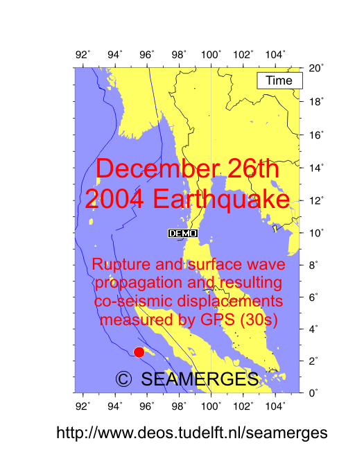
- Sumatra Eq.: Animation of rupture propagation monitored by cGPS
- India/Sunda motion :J. of Geophys. Res. article 06/05/2006
- Tsunami generation and propagation :Submitted to EPSL article 2007
 |
On the morning of December 26th, 2004 in SE Asia, 30 km below sea level, off the coast of northern Sumatra, Indonesia, the Earth crust ruptured with dramatic consequences for the surrounding countries. A major earthquake (the fourth in instrumental seismology history) just happened.
According to plate tectonics theory, Australia is moving at the Earth surface, colliding Asia at a velocity of about 8 cm/yr. The earthquake occurred on the oblique boundary between the Australian plate (near the separation with the Indian plate) and the Sundaland plate. Here the Australian plate plunges under the Indonesian islands of Java and Sumatra, in what geophysicist call a subduction.
Because it happened below sea level, the earthquake triggered a Tsunami: the motion of the sea bottom acts like a giant "kick" in the sea and generates high waves which travel across the ocean at an impressive speed of up to 700 km/hr. The direct effect of the earthquake was felt only in northern Sumatra, killing at least 100,000. The impact of the Tsunami is at the scale of the Indian Ocean: all surrounding countries (including Sumatra again) were hit by giant waves and flooding, killing at least 50,000 more.
In this report, we try to summarize available information and give clear and accurate scientific explanations about this disaster.
|
|
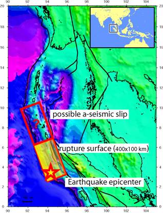
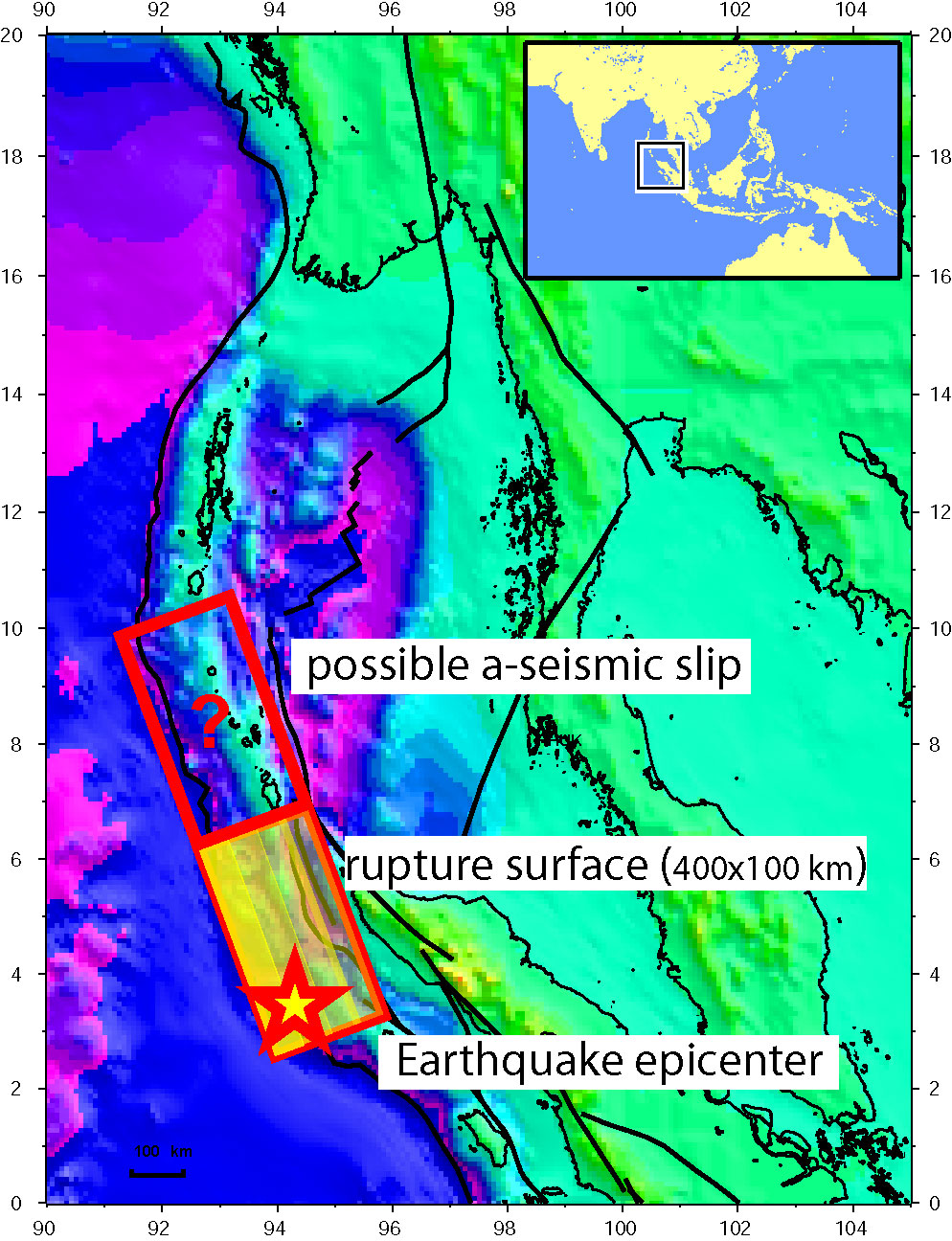
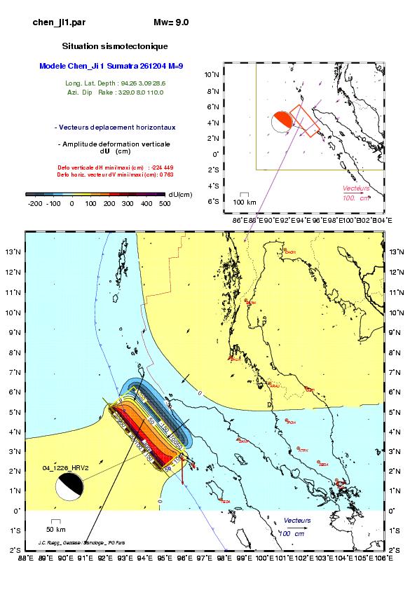
The earthquake ruptured a surface of at least 400 km long and 100km wide,
with an average slip of 10-15
meters, and local maximum of 20-25 meters. This gives a
magnitude Mw ~9. Some models use an even longer rupture, up to 800 km further north, almost
to the Andaman Islands. However, most of the
aftershocks (some of them being large earthquakes with magnitudes larger than
7) occur in this area, 1000
km north of the main shock. They may have been triggered
by ôsilentö slip of this portion of the fault, what they call a ôslow
earthquakeö. Whether this part of the fault really slipped is difficult to
infer from seismic records (rightly because the slip is "a-seismic"), but can
be investigated from the surface deformation measured by GPS. The dip angle of
the subduction plane interface is as small as 10°. This low angle explains why
the width is so large (>100km) and the magnitude so high.
The mechanism of a subduction earthquake cycle
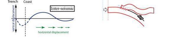 |
inter-seismic
at that stage, the 2 plates interface is locked by friction. The upper plate is accumulating elastic deformation at a slow rate (~1cm/yr). This loading phase can last for centuries
|
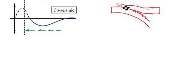 |
co-seismic
The earthquake releases in one moment deformation accumulated for centuries. At that stage, the upper plate "rebounds". the whole system being below sea level, this giant "kick" in sea water generates a Tsunami.
|
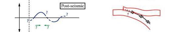 |
post-seismic
Return to equilibrium and steady loading can take years.
|
Seismic hazard in the area
 |
An earthquake in this area was not unexpected. The Sumatran subduction is where the convergence between the Indo-Australian plate and the Sundaland plate occur at 4-5 cm/yr. Large earthquakes (M ~ 8) occured in this area in the past (1907 and 1969). A magnitude 9 earthquake also occured further south on the trench in 1833.
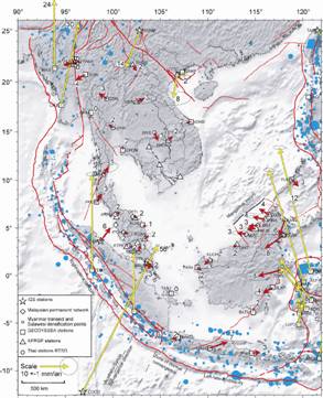
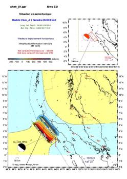
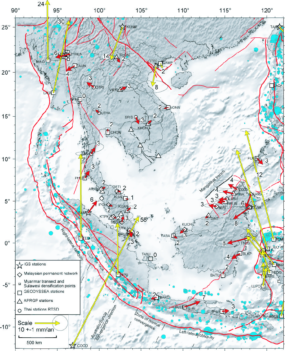
The figure in the left box depicts the crustal displacements and deformation pattern in SouthEast Asia, determined by GPS campaigns conducted under the GEODYSSEA and SEAMERGES programs since 1994 up to present (courtesy of W. Simons and A. Socquet, DEOS).
Yellow arrows in Sumatra depict the convergence. Red arrows span the Sundaland platelet. They show a rigid plate, moving independently from Eurasia, with deformed boundaries. Residual vectors near the boundaries are usually small (< 3 mm/yr) except in north Sumatra where the 6 mm/yr residual pointing inland (at station MEDA), indicates "high coupling" with the subduction.
This is in contrast with South Sumatra and Java, where residuals are smaller. This is probably related to the changing obliquity of the subduction and fact that the diping angle becomes almost 90° in Java.
|
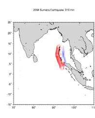
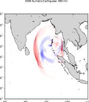
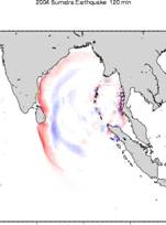
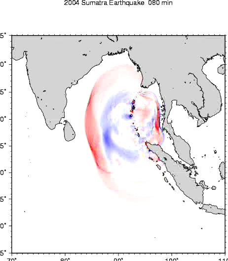
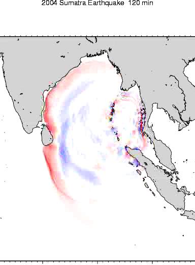
Tsunami propagation
The figures below show a numerical model of the propagation of the Tsunami generated by the Earthquake (Courtesy of Kenji Satake (National Institute of Advanced Industrial Sciences and Technology (AIST)). The red color means that the water surface is higher than normal, while the blue means lower. Because of the Fault geometry, the waves propagating to the East (towards Thailand and Myanmar) begin with a receding wave, which explains why the sea started to retreat minutes before flooding the coast. On the opposite, to the West (towards India and SriLanka) a large wave suddenly hit the coast without warning. 10 hours later, the Tsunami reached the African coast.
 |
 |
 |
| Step1 : a tsunami is generated by the motion of the sea bottom. The waves propagate Eastward and Westward. |
Step2 : 1 hour and 20 minutes later, the wave hits Phuket and the Indian ocean coast of Thailand and Myanmar. |
Step3 : Step3 : 2 hours later, the wave hits SriLanka and the East coast of India. |
Modeling and measurement of the co-seismic surface deformation.
Using Okada's elastic formulaes, it is possible to compute what should be the surface deformation depending on the hypothesis on the rupture itself (length, width, depth, strike, dip, etc...)
 |
| long. | lat. | dEast | dNorth | dUp | Site |
| 98.710 | 3.620 | -24.93 | -12.33 | 0.79 | SAMP |
| 100.280 | 6.450 | -9.56 | -6.61 | 1.42 | ARAU |
| 102.105 | 6.226 | -6.00 | -3.49 | 0.86 | GETI |
| 101.126 | 4.588 | -8.55 | -4.05 | 0.80 | IPOH |
| 101.718 | 3.171 | -6.21 | -2.14 | 0.15 | KTPK |
| 102.732 | 2.486 | -3.98 | -1.19 | -0.08 | SEGA |
| 103.640 | 1.566 | -2.54 | -0.68 | -0.24 | UTMJ |
| 98.304 | 7.759 | -10.93 | -11.20 | 1.77 | PHUK |
| 99.076 | 10.610 | -3.96 | -5.03 | 0.82 | BANH |
| 101.045 | 13.121 | -2.03 | -2.54 | 0.48 | CHON |
| 100.013 | 15.384 | -1.24 | -1.89 | 0.28 | UTHA |
| 97.715 | 16.938 | -0.75 | -1.45 | 0.10 | HPAA |
| 94.537 | 17.692 | -0.40 | -0.98 | -0.09 | LAUN |
| 97.820 | 0.571 | -2.28 | -2.86 | -6.20 | TEDA |
| 103.679 | 1.345 | -2.36 | -0.62 | -0.28 | NTUS |
The table gives the expected displacements (in cm) at selected GPS sites in Indonesia, Thailand, Malaysia and Myanmar. They are computed with the same parameters than the figure.
|
With a length of 450 km and a uniform slip of 11 m along the fault plane, horizontal surface displacement reach values of 10 cm, 1000 km away from the epicenter (figure and table courtesy of J.C. Ruegg, IPGP, France).
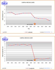
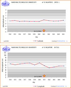
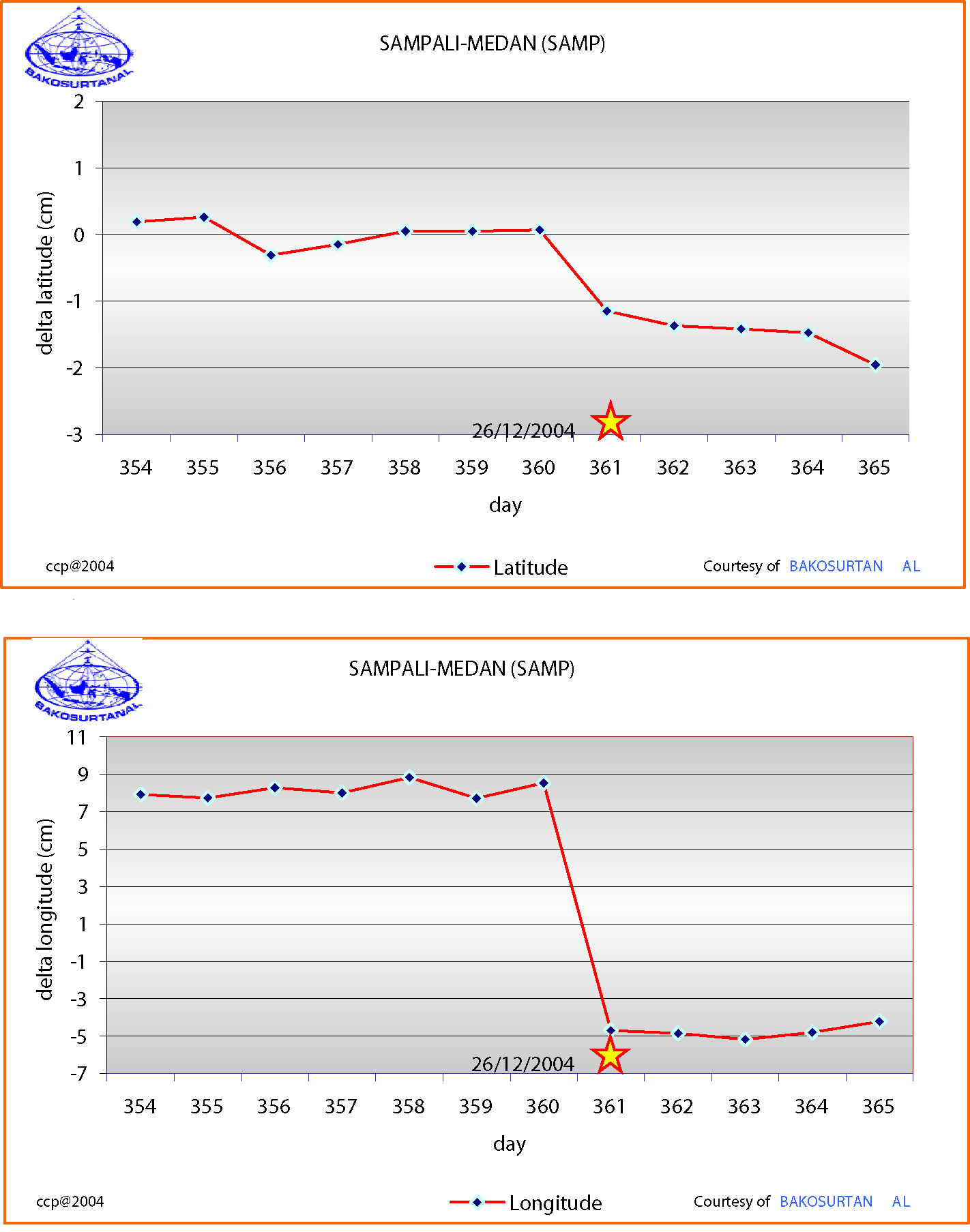
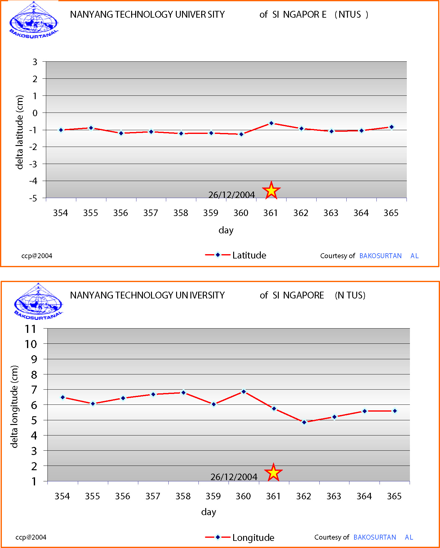
Today there are data available from 2 permanent GPS stations: SAMP (Sampali-Medan) in North-Sumatra from the BAKOSURTANAL Indonesian network, and NTUS in Singapore from the International GPS Service (IGS).
 |
 |
|
Preliminary data processing shows a displacement of around 15 cm to the WSW for SAMP and 2 cm towards NW for NTUS (courtesy of C. Subarya, BAKOSURTANAL). This is in rough agreement with the co-seismic elastic model.
|
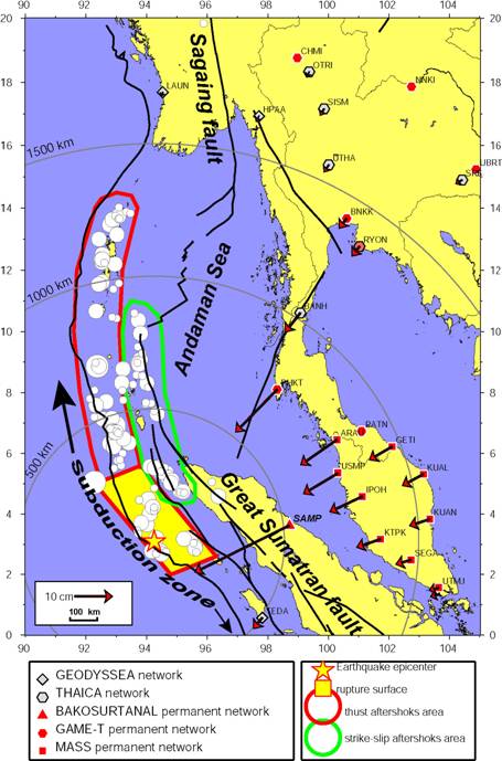 |
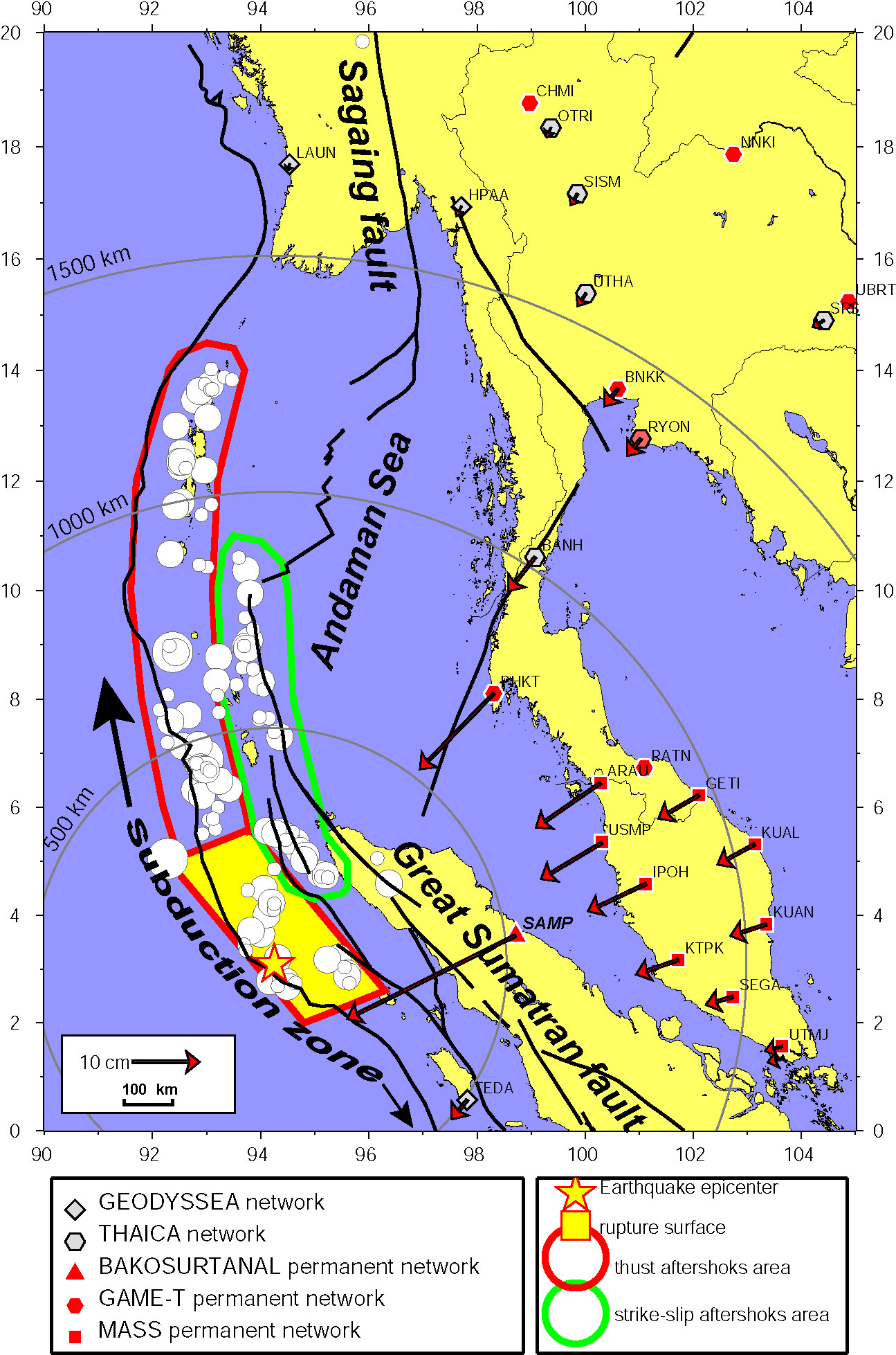
Permanent and campaign GPS networks in the area are depicted on the figure (left box).
It is clear that data from the Malay and Thai permanent networks will be extremely valuable to constrain the mechanism of the earthquake.
The model based on a 450 km long rupture predicts motions of 1-10 cm have affected most of the stations between 500 and 1500 km from the epicenter (red arrows).
Sites NE of the epicenter (PHKT or ARAU) are mostly affected.
Data From sites in Thailand and Myanmar will allow to determine if the rupture exceeded the 450 km assumed in the model.
The figure also depicts aftershocks up to January 4 (white circles).
Usually, aftershocks occur inside the main shock rupture area. They use residual stress and "clear" the small asperity left by the main rupture. In this case, it is very clear that aftershocks occur also out of the rupture area, spanning a zone 1000 km north of the epicenter (red contour). It may be that "silent" slip occurred there initially. In a more recent move, aftershocks also happened East of the main area (green contour), with different focal mechanism (strike-slip instead of thrust). Therefore, it is plausible that the earthquake which occurred on the subduction plane, loaded the whole system north and south, and transferred stress on the strike slip system behind the subduction. If correct, this poses an acute problem of seismic hazard on the great Sumatran fault (South) and on the Sagaing fault (North). Whether these motions really occurred during or after the earthquake can be investigated using surface deformation measurements provided by GPS. Both co-seismic measurements (Stations operating during the earthquake) and post-seismic measurements (stations installed after the earthquake) will provide crucial information on the earthquake mechanism and on follow-on scenarios.
|
A glimpse at the future
It is not very likely that a second major earthquake occurs very soon on the subduction. To the north, the whole plane apparently already slipped silently. However, this could happen to the South along the Sumatran coast. The occurrence of such an earthquake in the future is 100% sure, but precisely when is impossible to tell. It is clear that the remaining interface has been fragilized and that stress was increased. It could brake tomorrow or remain like this as a seismic gap for centuries. However, going to the south, the subduction is less and less oblique and the plane is diping more and more, with a friction coefficient which is less and less. As attested by the GEODYSSEA measurements in the south of Sumatra, the area of elastic accumulation is much smaller in the south than in the north. Therefore it can be speculated that a future earthquake in the south would be at least one order of magnitude smaller. Also, in that case a smaller Tsunami would not hit hard Sri-Lanka and India and would not reach Thailand, protected by the Island of Sumatra itself.
Large aftershocks in the Andaman Sea occur presently, some of them with a large magnitude (up to 7.5). They should settle slowly but can last for 2 or 3 months.
Last but not least, large earthquakes could be triggered by this event on the Great Sumatran Fault in Sumatra and on the Sagaing fault in Myanmar. But in any case, given the relatively shallow locking depth of these faults (15 km), those should remain smaller than magnitude 8.
Recommendation / Suggested Action Items
- Gather and process ASAP data from permanent tracking GPS stations in Malaysia, Thailand and Indonesia. This will allow to check and to adjust models of co and post-seismic deformation. Especially the existence of the "silent slip" area, north of the main rupture cannot be investigated with seismic waves because there are none, but can be detected from surface displacements in Thailand.
If existing, data at 1s sampling rate can be processed to monitor ground motion during the earthquake.
- Remeasure ASAP existing campaign markers with recent measurements before
the earthquake. This includes sites in Thailand and Myanmar for example and would help quantify the co-seismic motion.
- Install and or measure new or existing networks on the Sagaing fault in Myanmar and on the Great Sumatran Fault in Indonesia. This would allow to quantify a future co-seismic slip on these structure in case of an earthquake triggered by the Banda Aceh event.
- Install "temporary" continuous GPS stations where necessary. For example stations in the Andaman and Nicobar Islands could help monitor post-seismic slip and even detect pre-seismic motions of a future big aftershock in the Andaman sea. Stations in south Myanmar would allow to detect strain transfer from the Andaman sea to the Sagaing fault.
More information on http://neic.usgs.gov/neis/bulletin/neic_slav.html
SEAMERGES: South-East Asia: Mastering Environmental Research with GEodetic Space Techniques
Contract No: ASE/B7-301/1997/0178/16 (75442)
The following EC and ASEAN universities participate in the project:
- Department of Earth Observation and Space Systems (DEOS), Faculty of Aerospace Engineering, Delft University of Technology, Delft, Netherlands
- Laboratoire de Geologie, Ecole Normale Superieure (ENS), Paris, France
- Department of Geodetic Engineering, Faculty of Civil Engineering and Planning, Institut Teknologi Bandung (ITB), Indonesia
- Department of Geomatic Engineering, Faculty of Geoinformation Science and Engineering, Universiti Teknologi Malaysia (UTM), Malaysia
- Department of Survey Engineering, Chulalongkorn University, Bangkok, Thailand
In cooperation with the following external partners:
- National Coordination Agency for Surveys and Mapping Indonesia (BAKOSURTANAL), Cibinong, Indonesia
- Department for Survey and Mapping Malaysia (DSMM), Kuala Lumpur, Malaysia
- Royal Thai Survey Department (RTSD), Bangkok, Thailand
More information on SEAMERGES: http://www.deos.tudelft.nl/seamerges
ASEAN-EU University Network Programme (AUNP) is a joint initiative by the European Union (EU) and the ASEAN University Network (AUN) aiming to improve co-operation between higher education institutions in European Union Member States and ASEAN countries, and to promote regional integration within ASEAN countries
This document has been produced with the financial assistance of the European Union. The contents of this document are the sole responsibility of "laboratoire de Géologie at Ecole Normale Superieure" and can under no circumstances be regarded as reflecting the position of the European Union.
pdf version of this document
 Retour au sommaire
