In a nutshell…
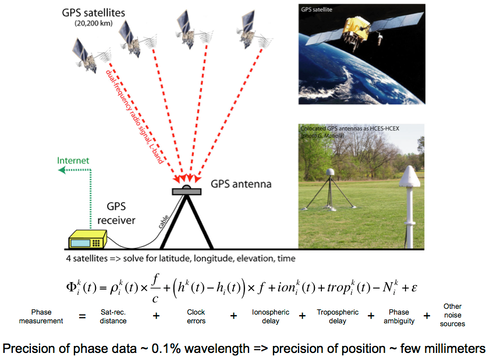
The Global Positioning System (GPS) is a space geodetic technique used for positioning and navigation, based on ranging measurements with a a constellation of 24+ satellites that broadcast a radio signal on two frequencies in the L-band. Using antennas setup on well-monumented benchmark and dual-frequency GPS receivers, it is possible to convert the satellite-antenna range measurements into positions with a millimeter-level precision. Consequently, repeated measurements of a network of sites that covers a region of active deformation provides a direct measurements of displacements and strain rates in the region.
Repeated episodic measurements of a network of survey sites is the classical approach for monitoring crustal deformation. The GPS technique permits the measurement of a large number of geodetic sites within a short time, typically 2 to 3 weeks (a GPS "campaign"). This strategy provides the displacement field over a region of active deformation with a dense enough spatial sampling to detect deformation gradients and short wavelength variations in the strain pattern, which are critical data to understand the physical processes controlling deformation and the hazard associated with active faults.
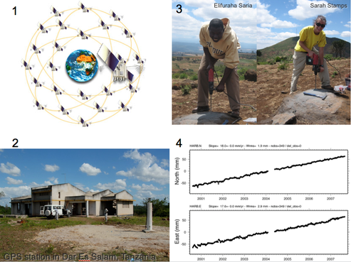
Continuous measurements at permanent GPS sites are an alternate strategy for high-precision GPS positioning. They provide continuous time series of the site positions, critical for the study of transient deformation. In the case of an earthquake, in particular, continuous GPS measurements provide unambiguous measurements of coseismic and postseismic deformation. Coseismic motions are critical to understand the seismic rupture characteristics, while postseismic motion provide key information on viscous relaxation processes in the lithosphere.
Applications of GPS measurements in geosciences abound. Measuring secular tectonic deformation comes to mind first, from the global or regional motions of ridig plates or blocks, to the accumulation of elastic strain at plate boundary faults. GPS measurements can also capture transient deformation signals, caused for instance by seasonal loading of the earth crust, postseismic deformation, or volcano-magmatic processes.