
Sources such as sub-surface and nuclear explosions, large volcanic eruptions, strong earthquakes, and rocket launches are known to excite atmospheric infrasonic waves. They generate acoustic and gravity oscillations that propagate laterally and upward, away from the source. These perturbations eventually reach the ionospheric layers, where the coupling between neutral atmosphere and ionized plasma results in fluctuations of the ionospheric electron density. Since the atmospheric density decreases almost exponentially with altitude, energy conservation implies that the pulse amplitude increases upward as it propagates into the atmosphere. For a near-surface source, for instance, the amplification factor can reach 10,000 at ionospheric heights.
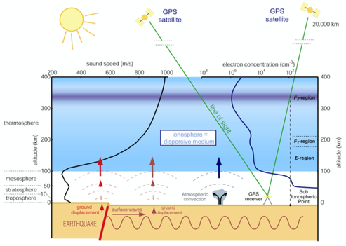
Detection of ionospheric disturbances is generally conducted using ground based HF sensors that probe the ionosphere below the peak electron density level. Because of its two L-band frequencies, the Global Positioning System (GPS) provides a way of directly measuring the Total Electron Content (TEC) in the ionosphere and, therefore, of detecting acoustic and gravity perturbations in the upper atmosphere. The main advantage of the GPS technique is to provide a measurement of the integrated electron content along the whole satellite/receiver line-of-sight at a large number of sites over a large geographic area. We demonstrated the capability of the GPS to detect ionospheric perturbations caused by earthquakes, rocket launches, mine blasts, and volcanic explosions.
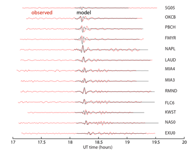
The development of permanent networks of densely spaced and continuously recording GPS stations provides the opportunity to investigate ionospheric perturbations and their characteristics at these higher resolutions. We have shown the possibilities offered by the Southern California Integrated GPS network, a densely spaced GPS array of about 250 stations, for the detection and analysis of ionospheric perturbations. We use methods derived from seismological array processing techniques to determine basic properties of the perturbations (propagation azimuth and velocity).
It has been proposed that earthquakes are preceded by electromagnetic signals detectable from ground- and space-based measurements. We have used two years (2003-2004) of continuous GPS data at 265 stations in southern California spanning the December 2003, M6.6, San Simeon and September 2004, M6.0, Parkfield earthquakes to search for precursory signals in GPS-derived TEC measurements. We find anomalous TEC signals but no statistically significant correlation, in time or in space, between these TEC anomalies and the occurrence of earthquakes. We show that some of the previously reported "precursors" are artefacts resulting from enhanced space weather effects.
Download our GPS-TEC code here (written in Matlab).