Calais, E., The Haiti 2010 Earthquake, McGraw Hill 2011 Yearbook, 2011.
On January 12, 2010, a Mw7.0 earthquake struck the Port-au-Prince region of Haiti killing more than 200,000 people, leaving more than 1.5 million homeless, and destroying most governmental, technical, and educational infrastructure throughout this region of 3 million people. It was also strongly felt in the Dominican Republic but caused no damage there because of the significant distance between major urban centers and the epicenter. The event caused an estimated $8 billion in damages in Haiti, ~120% of the country's GDP. No other earthquake of such moderate magnitude has ever caused so many causalities and such extensive damage. This was because the earthquake occurred in a heavily populated region of a very poor country with substandard building practices, and one that had not in any way prepared for such an eventually. Only limited information on the seismic hazard was available before the event. Efforts were underway to enhance communication and knowledge about earthquakes, but awareness among the public as well as decision- and policy-makers remained low. As a result, mitigation and preparedness efforts were minimal: earthquake threat was not accounted for in construction, land-use planning, or emergency procedures, a situation unfortunately common among earthquake-prone developing countries.
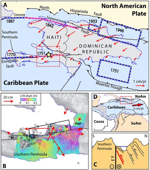
Though earthquake hazards may not have been on the minds of Haitians, the January earthquake came as little surprise to many geologists and geophysicists. Haiti — and the island of Hispaniola as a whole — lies on the boundary between two major tectonic plates, Caribbean and North America, which slide past each other at a speed of about 2 cm/year. This relative motion causes the build up of stress on several faults lines across the island. When the stress level exceeds the mechanical resistance of a fault section, the rock yields, resulting in a sudden break of the fault and the radiation of seismic waves away from this rupture: the earthquake. Historical archives tell us that this process occurred a number of times since Columbus first landed on Hispaniola. Southern Haiti was struck on September 15, 1751, November 21, 1751, and June 3, 1770 by major events, with magnitude estimated between 7.0 and 7.5, which severely affected Port-au-Prince. They were followed on May 7, 1842 by a magnitude 8.0 earthquake that struck the northern part of Haiti and Dominican Republic, with tremendous damage to the cities of Port de Paix and Cap Haitien. The most recent large events in Hispaniola is a series of magnitude 7.5 to 8.1 earthquakes between 1946 and 1953 offshore the northeastern coast of the Dominican Republic.
These large earthquakes highlight the three major fault systems that accommodate the relative motion between the Caribbean and North America plates. Studies based on Global Positioning System (GPS) measurements, a very precise technique that allows geophysicists to track Earth’s deformation with millimeter precision, show that the Caribbean plate moves east-northeastwards at a rate of about 2 cm/year relative to North America (DeMets et al., 2000). This overall plate motion consists mostly of horizontal shear parallel to the plate boundary, with a small amount of contraction perpendicular to it (Calais et al., 2002). The plate motion is distributed among a few major faults, with plate boundary-parallel motion accommodated by the Septentrional-Oriente and Enriquillo-Plantain Garden fault zones in Haiti and Dominican Republic, and plate-boundary normal (contractional) motion taken up offshore to the north of the island (North Hispaniola fault zone) and to the south of the Dominican Republic (Muertos trough) (Mann et al., 2002). Dense GPS measurements recently completed across the island show a north-south gradient in displacements, reflecting the build up of elastic strain within the Earth’s crust as a result of the overall plate motion. These measurements, when integrated into kinematic models (Manaker et al., 2008), indicate that the ~2 cm/yr relative motion between the Caribbean and North American plates is partitioned between 2 to 6 mm/yr on the North Hispaniola fault, 6 to 7 mm/yr on the Muertos trough, 12 mm/yr on the Septentrional fault zone, and 5 to 6 mm/yr on the Southern Peninsula fault zone (Manaker et al., 2008; uncertainties on these numbers are on the order of ±2 mm/yr). Additional faults, yet to be identified, may be active throughout Hispaniola – denser geodetic measurements and more geological investigations (on land and offshore) are needed to obtain the complete inventory of active structures necessary for seismic hazard assessment.
Historical archives indicate that the last major earthquakes to strike the Southern Peninsula fault zone in Haiti occurred in 1751 and 1770, about 250 years ago. Smaller magnitude earthquakes, which are less well located, occurred in 1701, 1784, 1860, 1864, and 1953 but these were too small to release much of the pressure building up in the fault zone. Assuming that the Enriquillo-Plantain Garden fault zone has been accumulating elastic deformation at a constant rate of 6 mm/yr (based on the GPS observations cited above), it had therefore built up, by 2010, a total amount of 1.5 m (0.06 m/yr x 250 yr) to be released in earthquakes to come. Earthquake scaling laws indicate that the release of 1.5 m of elastic deformation by sudden fault slip in one single earthquake corresponds to a magnitude of 7.1, very close to that of the January 12, 2010 event. This successful forecast of an earthquake magnitude based on geodetic measurements and historical data, while significant and useful, is far from being an earthquake prediction – this would require knowing the date and location of the event as well. It nevertheless demonstrates that scientific studies are critical to place useful bounds on the hazard level posed by seismic faults.
Within hours after the January 12, 2010, earthquake, preliminary results became available, in particular from the U.S. Geological Survey, which located the epicenter ~25 km (15 miles) WSW of Port-au-Prince and determined a magnitude of 7.0. On the basis of this location, most geologists and geophysicists assumed that the earthquake had ruptured a portion of the Enriquillo-Plantain Garden fault zone (EPGFZ), a nearly-vertical strike-slip (i.e. horizontal motion) fault that runs 900 km from the Enriquillo Valley of the Dominican Republic through the center of the southern Peninsula of Haiti and continues westward across the Jamaica Passage to the Plantain Garden valley of eastern Jamaica (Mann et al., 1995). This fault forms the southern boundary of the Gonave microplate, a small elongate plate wedged in between the larger North America and Caribbean plates in the northeastern Caribbean. Recordings from remote seismological stations were used to rapidly estimate the type of faulting, but with conflicting results regarding the dip of the fault plane; the USGS preferred dip to the south, while the Global CMT solution preferred dip to the north. Regardless of the solution, it quickly became apparent that the earthquake involved a large component of horizontal slip, but that some fault-perpendicular contraction was also present.
In the weeks following the earthquake several research teams were able to gain access to the field to study the geological context of the earthquake and assess the short-term threats associated with it. This fieldwork was made possible thanks to the efficient and dedicated participation of the Haitian Bureau of Mines and Energy and the Faculty of Science of the Haiti State University, both of which had however severely been affected by the earthquake. The mapping of surface breaks and measurement of ground displacements caused by the earthquake must be performed rapidly, as they are quickly overprinted by human activity, erosion, or post-earthquake deformation. A first-order priority was to document the surface rupture of the earthquake fault. Field observations from several independent groups, as well as extensive use of high-resolution satellite imagery found no surface expression of the earthquake fault along the geomorphically prominent trace of the EPGFZ. Therefore, despite the fact that the earthquake focus was relatively shallow, the associated rupture remained at depth and did not reach the surface. These early geological observations also identified uplift along the coast between Leogane and Petit Goave (up to 0.6 m) by mapping dead coral reefs that had emerged above sea level as a result of the earthquake.
Geodetic studies followed promptly, with the aim of measuring “coseismic” ground displacements – or simply put the difference between the position of the ground before and after the earthquake. This information helps constrain the geometry of the earthquake fault at depth as well as the overall distribution of slip during the earthquake rupture. GPS measurements at sites whose position had been determined pre-earthquake showed up to 0.8 m of horizontal displacement in the epicentral area (Figure B). Measurable coseismic displacements of a few millimeters were reported up to ~150 km from the epicenter. The spatial distribution of horizontal displacements showed a combination of left-lateral strike-horizontal motion and north-south contraction, in a pattern similar to the long-term (pre-earthquake) deformation across Hispaniola. Coseismic displacements were also well recorded by radar interferometry (InSAR), a remote sensing technique that compares satellite-to-ground range data from radar images taken before and after the earthquake. InSAR observations showed up to 0.8 m of satellite-to-ground range change over a ~50 km-wide region to the north of the EPGFZ and centered on Leogane (Figure B).
Taken together, the geological, seismological, and geodetic data indicates that the earthquake was caused by a ~30 km long rupture located between Petit Goave and Greissier, extending from 5 to about 20 km depth, and dipping 60o to the north. The same data require that motion on the earthquake fault combined horizontal shear (~2.6 m) and contractional motion (~1.8 m), with west- and up-ward displacement of the crustal block to the north of the fault (Figure B). More complex fault models are currently under investigation as more data become available, but all require that most of the slip occurred on a north-dipping fault slightly oblique to the vertical (or steeply south-dipping) EPGFZ. It therefore appears that most of the earthquake slip during the January 12, 2010 event did not occur on the Enriquillo fault, contrary to original assumption right after the event. Clearly, more analysis is required to finalize these conclusions and understand their implications for earthquake hazard in Haiti.
The January 12, 2010 earthquake was followed by a strong sequence of aftershocks (Figure B), with magnitudes reaching 5.9 (01/20/2010) so far. In the absence of a national seismic network in Haiti, it was key to install temporary seismic stations to study the spatial and temporal distribution of the aftershock sequence. A French group (Géoazur, Ifremer, and IPG Paris) was able to install ocean bottom seismometers (OBS) four weeks after the earthquake on either sides of the southern Peninsula of Haiti. Shortly after, they installed five seismic stations on land between Port-au-Prince and Miragoane, which remained in operation until May. Seismologists from the Canadian Geological Survey installed 3 seismic stations in Port-au-Prince, Leogane, and Jacmel in mid-February, meant to remain in operation for the long-term. In March, the U.S. Geological Survey deployed eight seismometers outside of Port-au-Prince (removed i June ) to increase aftershock detection and improve location estimates, and six strong-motion instruments within Port-au-Prince to investigate the variability of shaking associated with variations in local geology and topography (five will stay for the long-term). Although work remains to be done to fully characterize the aftershock sequence, preliminary results indicate that they concentrated at the western end of the rupture (between Leogane and Miragoane). Most of them involve faulting on NW-SE trending faults with pure contractional motion, another surprise given the mostly strike-slip nature of the main shock.
The January 12, 2010 Haiti earthquake was a tragic reminder of geological reality: the inexorable seismic threat to which the country and the region are exposed. The threat is as old as the active fault lines that cut through Hispaniola, and will remain present as long as the Caribbean and North American plates continue to move past each others at speeds of about 2 cm/yr, for the next millions of years. This part of the risk equation, driven by the slow but inexorable drift of tectonic plates, is non-negotiable. The remaining part of the risk equation, the population exposure and vulnerability, is the responsibility of governments, international agencies and, increasingly, the actions taken by local communities and individuals. Experience and research have given us a broad range of solutions to reduce these factors. These involve proper land-use planning, appropriate use of construction codes, and raising public and institutional awareness through education and research. But the effective application of such mitigation strategies requires a strong and sustainable science and engineering foundation in Haiti, so that Haitians themselves can take a lead role in quantifying the threats and designing solutions adapted to their economy and society. The international community has the responsibility of helping Haiti implement these solutions in every aspect of its reconstruction.
Bibliography
Calais, E., Y. Mazabraud, B. Mercier de Lépinay, P. Mann, G. Mattioli, and P. Jansma, Strain partitioning and fault slip rates in the northeastern Caribbean from GPS measurements, Geophys. Res. Lett., 29(18), 1856, doi:10.1029/2002GL015397 (2002).
DeMets, C., P.E. Jansma, G.S. Mattioli, T.H. Dixon, F. Farina, R. Bilham, E. Calais, and P. Mann, GPS geodetic constraints on Caribbean-North America plate motion, Geophys. Res. Lett., 27, 437-441 (2000).
Manaker, D. M. et al. Interseismic plate coupling and strain partitioning in the northeastern Caribbean. Geophysical Journal International 174, 889–903 (2008).
Mann, P., Taylor, F., Edwards, R. & Ku, T. Actively evolving microplate formation by oblique collision and sideways motion along strike-slip faults: An example from the northeastern Caribbean plate margin. Tectonophysics 246, 1–69 (1995).
Mann, P. et al. Oblique collision in the northeastern Caribbean from GPS measurements and geological observations. Tectonics 21, 1057 (2002).