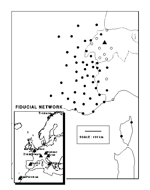
Alpes93 GPS network. Triangles are for the IGS fiducial stations used in the analysis (8). Dots are for the French measured stations (50). Open circles are for the Swiss and Italian stations not included in this analysis (11). The lower left corner box shows the European fiducial network where the shaded area depicts the Alpes93 network area.


ALPES93 GPS site coordinates in WGS84 in degres, minutes, decimal secondes
No COUNTRY CODE LATITUDE (DMS) LONGITUDE (DMS) ALTITUDE(M) COMPLETE NAME
1 Fr ARC0 47 2 44.7 6 22 24.3 855.8 ARC-SOUS-CICON
2 Fr AUF0 45 59 36.3 6 29 15.6 1660.4 AUFFERAND
3 Fr AUS0 45 13 23.3 6 44 29.6 1549.5 AUSSOIS
4 Fr BAU0 43 9 48.4 5 53 24.8 596.3 BAOU DE QUATRE AURES
5 Fr BSB0 42 1 27.1 8 43 57.4 515.6 BOCCA SAN BASTIANO
6 Fr CAU0 43 45 16.6 6 55 14.6 1318.2 CAUSSOLS
7 Fr CBR0 44 8 17.1 4 17 11.8 572.6 COL DU BOURRICOT
8 Fr CDM0 45 31 22.1 6 3 53.8 1097.6 COL DU MONT
9 Sw *CET 46 48 6 30 1222. COL DES ETROITS
10 Fr CEY0 46 12 18.6 5 20 31.4 580.7 CEYZERIAT
11 Fr CFE0 45 13 31.6 6 12 25.6 2098.3 COL DE LA CROIX DE FER
12 Fr CHA0 43 59 18.2 6 19 38.4 966.4 CHAUDON
13 Fr CHP0 44 44 4.1 6 34 12.2 1184.1 CHAMPCELLA
14 Sw *CHS 47 09 7 04 1649. CHASSERAL
15 Fr CLB0 44 12 12.8 7 9 12.9 2468.5 COL DE LA LOMBARDE
16 Fr CPA0 44 6 14.2 3 39 26.9 908.0 COL DU PAS
17 Fr CRM0 45 45 35.7 5 28 11.1 274.3 CREYS-MALVILLE
18 Fr CSP0 43 47 34.0 7 24 1.5 730.3 COL DE SAINT PANCRACE
19 Fr CTA0 44 41 3.8 5 54 40.4 1730.1 COLLET DU TAT
20 Fr CUE0 45 52 52.3 5 45 27.5 1483.1 CUERME
21 Fr CXP0 46 57 55.6 5 53 10.7 837.8 CROIX DE POUPET
22 Fr DTG0 45 47 40.0 6 6 31.1 1641.8 DENT DU GONVY
23 Sw FAH0 47 24 35.0 6 56 55.1 633.6 FAHY
24 Fr FIX0 47 14 34.1 4 57 18.6 487.0 FIXIN
25 Fr FUR0 44 53 32.4 5 19 21.7 1554.7 FONT D'URLE
26 Sw GIV0 46 27 14.7 6 6 7.4 1257.9 COL DE LA GIVRINE
27 Fr GMN0 43 58 33.3 4 45 59.0 240.2 LE GRAND MONTAGNE
28 Fr GRC0 46 26 57.9 4 42 52.7 557.2 LA GRANDE ROCHE
29 It *IMP 43 52 8 02 75. IMPERIA
30 Sw *JEI 46 18 7 36 1584. JEIZINEN
31 It LAU0 44 53 3.5 7 7 18.8 2331.7 PUNTA LAUZARO
32 Fr LCH0 44 32 12.0 6 47 4.0 1695.3 LE CHATELET
33 Fr LUB0 43 48 13.3 5 8 59.1 699.2 PETIT LUBERON
34 Sw MAR1 46 6 17.2 7 4 7.5 593.4 MARTIGNY
35 Fr MAZ0 42 38 48.0 9 18 6.3 235.2 MONTE A MAZZOLA
36 It *MIL 45 17 9 08 120. POLITECNICO MILANO
37 Fr MPA0 43 13 10.1 6 36 3.8 368.0 MOULIN PAILLAS
38 Fr MTC0 45 6 00.0 5 46 2.8 781.5 MONTCHABOUD
39 Fr NCH0 47 47 40.8 5 22 3.0 501.3 NOIDANT-CHATENOY
40 It NIV0 45 28 44.4 7 8 34.4 2680.7 COL DU NIVOLET
41 Fr PEC0 44 14 53.7 6 3 6.0 1274.0 PAS DE L'ECHELLE
42 Fr PLJ0 46 11 52.7 6 27 56.0 1314.7 PLAINE JOUX
43 It PRN0 44 15 3.3 7 47 19.5 1693.9 PRATO NEVOSO
44 It PSB0 45 39 11.5 6 51 57.1 2430.3 PETIT SAINT BERNARD
45 Fr PUB0 46 38 46.6 5 38 36.6 567.4 PUBLY
46 Fr RPA0 44 45 51.1 4 24 40.8 1131.5 ROCHER DE LA PAILLERE
47 Fr RPE0 47 18 50.9 4 0 26.9 597.3 ROCHER DE LA PEROUSE
48 Fr RSL0 45 41 29.7 6 37 41.8 1693.4 ROSELEND
49 Fr RVE0 43 22 30.3 5 17 23.8 325.5 LE ROVE
50 Fr SAR0 45 52 37.4 4 32 19.0 382.0 SARCEY
51 It SGG0 45 39 30.3 7 59 30.8 1095.4 SANTUARIO SAN GIOVANNI GALLERIA
52 Fr SJU0 43 41 35.5 5 54 16.8 616.0 SAINT JULIEN LA MONTAGNE
53 Fr TCH0 47 54 57.9 6 49 38.1 1046.1 TETE DES CHAMPS
54 Sw *TRE 46 36 7 04 804. LA TOUR-DE-TREME
55 It *TUR 45 03 45.1 7 39 41.8 326.8 POLITECNICO TORINO
56 Fr VER0 44 18 7.6 5 20 33.6 681.2 VERCOIRAN
57 Fr VIR0 45 17 9.1 5 12 3.3 601.2 VIRIVILLE
58 Sw ZIMM 46 52 37.5 7 27 55.1 956.0 ZIMMERWALD
- Distances between stations correspond to a centimetric repeatability. On the opposite, absolute positions uncertainties can be as high as a couple of decimeters.
- Computations were done by christophe Vigny with the GAMIT software version 9.3, exept for the sites which names are preceeded by a *, which coordinates are very approximative.


The Alpes93 GPS Campaign

The GPS campaign was conducted during September 1993. 50 sites were measured with 22 dual frequency Ashtech receivers and 1 Rogue. 41 sites were occupied for 4 twelve-hours sessions and 6 sites were measured for 6 twelve-hours sessions. Continuous measurements were made at the 3 remaining sites during the 12 days of the campaign. In addition. The main interest of those 3 "fixed" sites and the 6 previous ones, is to allow to link sites which were not measured simultaneoulsy. This is the classic scheme when there are more sites to measure than receivers available. Eventually 700 baselines out of the possible 1275 were actually measured at least 4 times.


Thanks to reasonable weather conditions almost all planned observations were conducted. Because of the absence of Anti Spoofing (AS) at the time, most of the data include precise P-code observations.
Sixteen of our sites belong to the new French Reference network (R\'eseau de Base Fran\c cais - RBF) and both during and immediately after this campaign, twenty five other sites were tied by GPS measurements to the closest sites belonging to the French geodetic network (Nouvelle Triangulation de la France - NTF). This classical triangulation network is maintened by the french mapping agency (IGN) since 1873 in some parts of France and mainly since the 1950's in the French Alps. We expect to be able to detect site motion higher than a couple of millimeter per year from the comparison of present days positions to those historical measurements.
Independent measurements were conducted by Swiss and Italian teams at the same epoch. Because the session schedules were different, few observations were made simultaneously. We therefore decided to process the three data sets independently and only combine the three corresponding solutions. Here, we only report on the French measurements.


Data Analysis

All the GPS data analysis described here is conducted with the GAMIT / GLOBK software from MIT (King and Bock 1993, Herring 1993). In order to provide a robust reference frame, the specific alpine data is merged with International GPS Geodynamics Service (IGS) data from 8 European stations (see fig. 2). Both station positions and satellite orbital parameters are estimated in our solution. No field meteorological data is used to compute troposphere induced propagation delays, we instead use the data itself to estimate one "atmospheric parameter" every two hours.
The data is first processed on a day to day independent sessions basis. Using approximate input station positions and satellite ephemerides, we compute a first solution for every day. This solutions enables us to "clean" the data, i.e. detect and repair all cycle-slips, and unweight bad data (contaminated with heavy multipath for example). Most of the carrier-phase ambiguities are usually resolved.
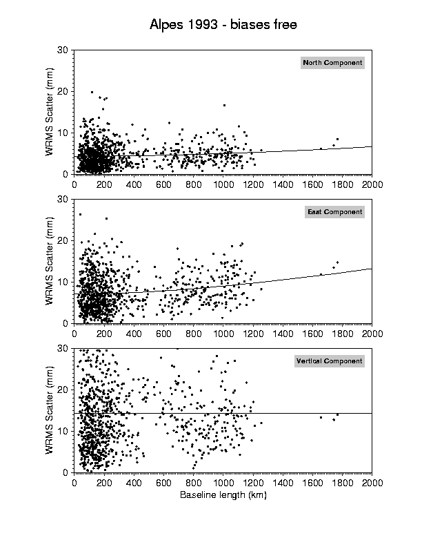
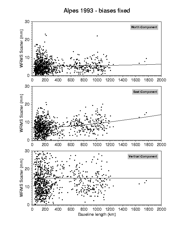
Each of these solutions provides an independent estimation of the baseline components. Figure 3 shows the "repeatability" for the alpine stations, plotted against baseline length. That is, for both horizontal and vertical components of each baseline, the dispersion or scatter of the independent measurements about their mean value. This repeatability is a first insight to what the precision of the measurements really is. The solution depicted here is "biases-fixed", i.e. phase ambiguities are fixed to integer values. As expected, this scheme involves an improvement of the repeatability of the baselines east component. The thin line in each box represents the "average" repeatability and shows its dependency with the length of the baselines.

Alpes 93 - IGS orbits


Repeatability plot: Weighted root mean square scatter about the mean value in mm, plotted against baseline length in km. The upper box is for the north component, the middle box for the east component, and the lower box for the vertical component.


Here, the repeatability of the two horizontal components is slightly affected by the baseline length: .02 ppm for the north component and .03 ppm for the east component. Although these numbers are small, this is mainly due to the fact that the orbits are not determined precisely enough. Further improvement of the orbits will be obtained from additional computations described later. Nevertheless, the threshold value shown by the smaller baselines will remain unaffected and these figures set the intrinsic quality of the data. For almost all baselines smaller than 200 km, the horizontal repeatability is better than 10 mm. The mean value is 5 mm for the north component, and 9 mm for the east component. We expect all baselines to reach those values when the orbits are fully precisely determined. The vertical component (20 mm) is not as good as the horizontal. The increase of the scatter is due to the fact that vertical GPS measurements are more affected than horizontal measurements by tropospheric activity, poor geometry of the satellite constellation, and uncorrect antenna heights.


Further Processing

As commented before, some additional work is needed and will be done in order to improve the precision of the solution. This improvement will come mainly from a better determination of the satellite orbits. There are two ways to achieve this: the first one is to combine the independent day-to-day sessions in order to compute multi-days (and therefore more precise) orbital arcs, the second one is to add more fiducial data from IGS stations all over the world. The later will not be done by merging more carrier phase measurements to the inversion which would turn the data processing into an impossible task, but rather by merging the Variance-Covariance matrices of our solution and of an IGS center solutions. The GAMIT / GLOBK software provides a very easy way of doing so through a Kalman filter. We will use the SCRIPPS Institute of Oceanography (SIO) solution, also computed with the GAMIT / GLOBK package, available on line through the Ethernet network. This solution currently contains 35 IGS stations globally distributed.
Eventually, the Swiss and Italian data sets will be added to our processing by the same means, i.e. independent daily GAMIT solutions combined all together with the Kalman filter. We will then have established a robust network of 61 stations, with reference positions at September 1993.
The sixteen sites belonging to the RBF were remeasured during the second semester of 1994 and will be repeatedly measured by the IGN in the future as part as the French geodetic network. This almost continuous surveyance will provide the first insights on site displacements and help us to planify the future remeasurement of the hole network.


Data Archives

All data relative to the ALPES93 campaign are archived at Ecole Normale Sup\'erieure (ENS), Paris, France. They are accessible through Ethernet Network and specific request directed to the authors. Archives include raw data, compressed RINEX files, digitalized log sheets and station descriptions, and precise orbits from all IGS centers for the corresponding period (1993 days 248-260, GPS weeks 712-714). "Cleaned" (i.e. cycle-slip free) RINEX data files, precise station positions (centimetric precision), and Variance-Covariance solution matrices (H-files in GAMIT jargon) will also be included.
The publication of a CDROM is considered for diffusion and long term conservation of the data. This CD will contain all the archives described above, including cleaned data files and solutions.


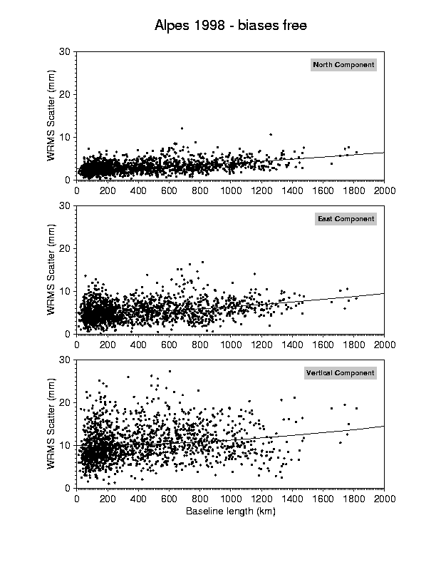
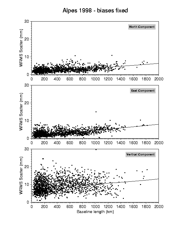
1998 campaign results

Alpes 98 - IGS orbits


article EOS : GPS Network Monitors the Western Alps. (ALPES93 campaign)