Island Arc special Publication
"Recent deformation at the junction
between the North Luzon block and the Central Philippines, from ERS-1
images"
M. Pubellier
(1), F. Garcia (2) , A. Loevenbruck (1) , J. Chorowicz (2)
(1) : CNRS,
UMR 8538, Laboratoire de Géologie, Ecole Normale Supérieure, 24 rue Lhomond
75231 Paris Cedex 05 France.
(2) :
Département de Géotectonique, CNRS ESA 7072, T 26-16 E1, Université Pierre et
Marie Curie, 4 Place Jussieu 75252 Paris France.
Abstract
The transfer of the major part of the motion
between the Philippine Sea Plate and the Sunda block is accommodated along a NW
shear wide zone partly on the Philippine Fault and partly on the Sibuyan Verde
Passage Fault (SVPF) as indicated by GPS and geological data. Given the limited
motion along the SVPF and the important motion along the Philippine Fault, as
well as the necessity of a connection between these faults and the southern
Manila Trench, a transtensional motion along the NE-SW Macolod Corridor may be
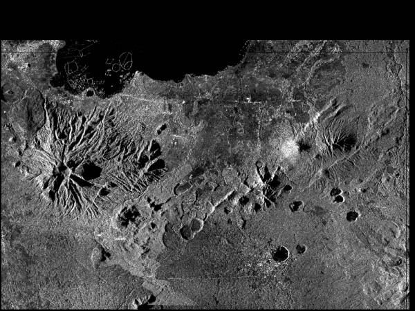
predicted. We make use of SAR ERS-1 images to analyse the volcano-tectonic
features of this area because these images are sensitive to minute textural or
topographic contrasts resulting from small effects of recent deformation. In
addition they allow to determine accurately the shape of the base of volcanic
edifices and to detect linear clusters of very small adjascent cones (Chorowicz
et al., 1997).
 The results presented herein allow us to extend the
features recognized earlier to a larger Macolod Corridor. Large faults actually
connect the Philippine Fault to the Sibuyan Verde Passage Fault all accross the
Taal Volcanic Field. In addition to extension along NE faults, we identify an
important component of left-lateral strike-slip underlined by fault scarps,
dykes, alignments of volcanoes and pull-apart basins, accompanied by extension
along N-S faults. A relative chronology of the fractures and volcanic edifices
is proposed. When compared to the existing ages of the volcanics, an evolution
scheme of the area may be proposed, according to which extension shifted from a
nearly N-S opening between 5 and 2 my to a direction close to E-W at Present.
The early N-S extension existed in the Marinduque Basin and may have migrated
northward and rotated to the present Macolod Corridor.
The results presented herein allow us to extend the
features recognized earlier to a larger Macolod Corridor. Large faults actually
connect the Philippine Fault to the Sibuyan Verde Passage Fault all accross the
Taal Volcanic Field. In addition to extension along NE faults, we identify an
important component of left-lateral strike-slip underlined by fault scarps,
dykes, alignments of volcanoes and pull-apart basins, accompanied by extension
along N-S faults. A relative chronology of the fractures and volcanic edifices
is proposed. When compared to the existing ages of the volcanics, an evolution
scheme of the area may be proposed, according to which extension shifted from a
nearly N-S opening between 5 and 2 my to a direction close to E-W at Present.
The early N-S extension existed in the Marinduque Basin and may have migrated
northward and rotated to the present Macolod Corridor.