© projet GPS ALPES
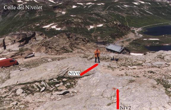
N.37 - COLLE DEL NIVOLET

Lat. : 45 28' 44.48251   Long. : 07 08' 33.67472 	Alt. : 2681.48 m

Carte :	Colle del Nivolet   F.41, III NE  della carta d'Itallia (1948)
access :
From Ivrea it takes about 2 hours by car. You must follow the signals to
Bellamonte and then to Locana and Ceresole. Once the Ceresole, Serru and
Agnel lakes have been passed you will get to the "Rifugio Citta di Chivasso"
managed by the Club Alpino Italiano (CAI). You can park your car in the
parking (located on the right side of the road) close to the shelter.
On the outcrops located on the right of the parking (at a distance of about
30 meters) you will find the GPS markers. The markers are located at a
distance of about 80 meters from the shelter (see picture and map).

GPS reference site:
It has been realized by spikes made of stainless steel. The head of the
spikes have the shape of a semisphere with a small hole on the center.
(July 28th 1993. M.Anzidei and L.Giovani).
All the spikes are marked by a red paint. On a rock close to the parking is
reported "GPS" by a red paint.

Geology : Piemontese area. Gneiss.

housing:
You can house in the "rifugio Citta di Chivasso" (close to the GPS markers)
or in the "rifugio Savoia" (located at about 500 meters from the markers).
The "rifugio Citta di Chivasso" is open till the middle of Septernber ;
the "rifugio Savoia" is open till the first week of October.

"Rifugio Citta di Chivasso" (Club Alpino Italiano)  Tel. 0124-95 31 50
telephone and restaurant are avalaible (not electricity 220V and hot water) .
Colle del Nivolet
10010 Valsavarenche (AO), Italy

"rifugio Savoia"  Tel. 0165-94 141 (telephone, electricity 220V, restaurant
and hot water are avalaible).
Colle del Nivolet
10010 Valsavarenche (AO), Italy

To house in the"rifugio Savoia"   you can also contact :
Famiglia Dayne
via E. Chanoux  n. 16
11018 Villeneuve (AO), Italia

		Lat.		Lon.		Alt.
NIV0		45 28 44.48251	07 08 33.67472	2681.48
NIV1		45 28 44.58109	07 08 33.59542	2680.91
NIV2		45 28 44.24259	07 08 33.79189	2683.13
NIV3		45 28 44.43628	07 08 33.49486	2681.79
© projet GPS ALPES