Monitoring of the Sagaing Fault (Myanmar):Installation of a GPS Network in the Mandalay areaA sub contract within the GIAC program |
1 Tectonic Settings
The Sagaing fault is a major right-lateral strike-slip fault running North-South in Central Myanmar. This fault accomodates all or part of the differential motion between India and Eurasia (more precisely the Sunda platelet) in this area.
In order to study the Sagaing fault and analyze the local deformations and seismic hazards, a local GPS network was installed in the area. This local network is tied to the main GEODYSSEA network, in order to be able to analyze local displacements in the frame of the large scale plate tectonics. This is particularly important around faults where a reference velocity is needed for the interpretation of the local deformations.
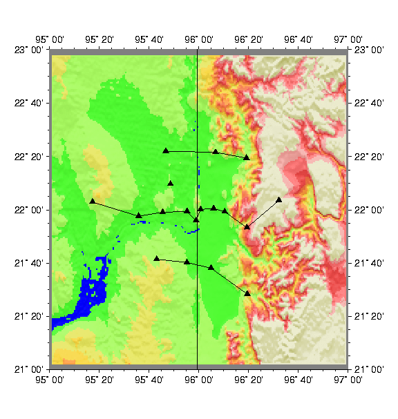
This local network is made of three transects across the Sagaing fault at the latitude of Mandalay. One long transect (10 points, 150 km) sample the deformation in between the 2 north points of the GEODYSSEA network. Two shorter transects (4 points, 60 km each) sample the deformation 30 km North and South of the main transect. The displacements between points from one given transect will allow to localize the position and constrain the locking depth of the active fault. The displacements between points along the fault will allow to detect active segments of the fault and measure co-seismic motions, in case of an Earthquake in this area of the fault.
2 Reconnoissance Field Trip
The field trip took place between February 14th and March 2nd (16 days), 1997. During those 2 weeks, 18 sites were installed, half of which required concrete monumentation. The success of the geodetic mission can be attributed to the dedication of everyone in the team despite bad road conditions, car brake down, driller failure, etc...
The reconnoissance and installation team was made of the following individuals :
| Scientists : | - from France : | - | Christophe Vigny (geodesist) |
| - | Guillaume Bertrand (geologist) | ||
| - From Myanmar : | - | U Min Khaing (geologist) | |
| - | U Aye Ko (geologist) | ||
| Logistics : | 11 persons from Myanmar (1 medical doctor, 1 head of logistic + 4 assistants and drivers, 1 cook + 2 assistants) | ||
The 18 sites for such a local network don't need to be as cautiously chosen and monumented as the 4 sites of the large scale network. The destruction of any of them represent a much lighter loss for the network. Therefore only one main marker per site is implemented, which does not require large benchmarks or tie measurements. | 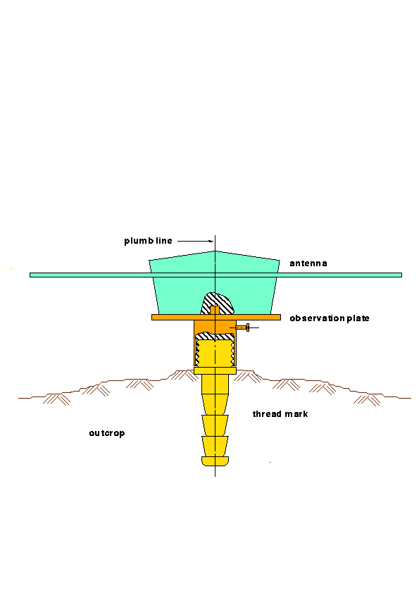 marker and antenna binding | ||
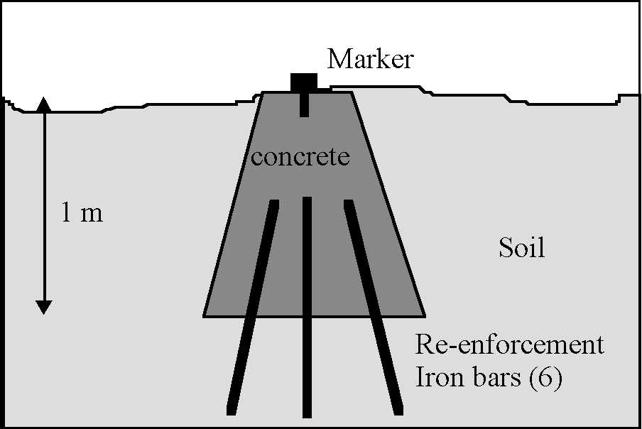 Concrete benchmark sketch map | |||
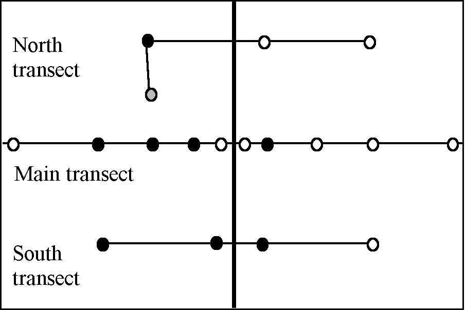 Sketch map of the network: black dots for concrete benchmarks (8), grey dot for boulder (1), white dot for bedrock (9) |
4 Measurement Planning
The Local network was measured immediately before the main GEODYSSEA network, using the GPS equipment shiped to Myanmar by IFAG for the main campaign. Such agreements have already been carried out in the Philippines or Indonesia and revealed very efficient in saving time money and management.
The measurements took place during 21 days, from Tuesday November 3rd to Tuesday November 24th. During this time span, an absolute prioruty was given to the GEODYSSEA network (Taunggyi, Mindat, Hpa-an, Launggyo), which must be measured for 5 continuous days from November 19th 08:00 AM to November 24th same time. Priorities were then established as following :
| Personel required : | - | 4 geodesist (german from IFAG or french from ENS) |
| - | 4 Myanmar counterparts | |
| Equipment required : | - | 4 cars |
| - | 4 GPS sets of equipment (receiver, battery, etc...) provided by IFAG | |
| Schedule : | |||
| day 1 | dispatching and testing of the equipment at headquarters | 1 day | |
| days 2->7 | measurements on the main transect | 6 days | |
| days 8->10 | measurements on the North transect | 3 days | |
| days 11->13 | measurements on the South transect | 3 days | |
| TOTAL | 13 days | ||
Since the distances between points are short, only 1 day of continuous measurements on each site is required to achieve millimeter accuracy. Nevertheless, redundant measurements are required in order to realize ties between the different figures of 4 points. Therefore, throughout the campaign, 3 points are hold fixed: Throughout the campaign, 3 points are hold fixed :
the 2 remaining receivers, row from one point to the other.
The local campaign lasted 13 days. The most important baseline in the network being the longest one across the fault,(in order to get the far field displacement), we choose to hold points Kweh-Taing-Taung (KWEH-01) and Ywe-Nge (YWEN-10) fixed. Additionaly, the spare receiver as left acquiring data unattended at Mandalay polo ground (MDPG-07). This receiver could have been requested to replace any other one any time anywhere in case of brakedown (which indeed happpened later).
| Main transect measurements : | ||||||||||
| DAYS | SITES (10) | |||||||||
| 01-KWEH | 02-HTIS | 03-LEGY | 04-SAYE | 05-TNYO | 06-LEPA | 07-MDPG | 08-YANG | 09-ZIBI | 10-YWEN | |
| day1-03/11-307 | T1 | T3 | Spare | T4 | T2 | |||||
| day2-04/11-308 | T1 | T3 | Spare | T4 | T2 | |||||
| day3-05/11-309 | T1 | T3 | T4 | Spare | T2 | |||||
| day4-06/11-310 | T1 | T3 | T4 | Spare | T2 | |||||
| day5-07/11-311 | T1 | T3 | Spare | T4 | T2 | |||||
| day6-08/11-312 | T1 | T3 | Spare | T4 | T2 | |||||
| North transect measurements : | |||||||
| DAYS | SITES (4 + 3 fix) | ||||||
| 01-KWEH | 11-THIT | 12-WETL | 07-MDPG | 13-BODA | 14-KUNT | 10-YWEN | |
| day7-09/11-313 | T3 | T1 | Spare | T2 | T4 | ||
| day8-10/11-314 | T3 | T1 | Spare | T2 | T4 | ||
| day9-11/11-315 | T3 | T1 | Spare | T2 | T4 | ||
| South transect measurements : | |||||||
| DAYS | SITES (4 + 3 fix) | ||||||
| 01-KWEH | 15-MYOT | 16-CHAU | 07-MDPG | 17-NYAN | 18-KINV | 10-YWEN | |
| day10-12/11-316 | T3 | T1 | Spare | T2 | T4 | ||
| day11-13/11-317 | T3 | T1 | Spare | T2 | T4 | ||
| day12-14/11-318 | T3 | T1 | Spare | T2 | T4 | ||
During the reconnoissance and installation field mission, it was discovered that an old triangulation network existed in the Mandalay area. If the classical geodetic type measurements are still accessible (angle and distance measurements), it is possible to recompute the position of these pillars back in time with a reasonnable accuracy. Such experiences were conducted on the hold french triangulation networks and proved feasable. In such case, it would be very profitable to re-occupy the still existing pillars by modern means (GPS) to infer their present day positions. given the millimitric accuracy of todays methods, and the very long time span elapsed since the first classical measurements (more than 50 years), rates up to a couple of cm/yr could be easely detected. Such a work requires very little effort, since the old geodetic pillars could be surveyed by GPS very easely, during and/or following the GPS network survey. the only serious requirements are :
Another interesting possibility would be to take advantage of the existing railway track (from Monywa to Pin Oo Lwyn) to measure a topographic profile across the Fault at the latitude of the main transect. Such a profile can be measured very easely and accurately by GPS kinematic methods. One receiver is hold fixed at a reference point (eg. Mandalay Polo ground) and a mobile receiver can be set up on the roof of a railway car. Measuring frequently the position of both receivers (eg. every second), one can reconstruct the trajectory of the mobile with respect to the fixed one, with a centimetric accuracy. From this trajectory one can extract the profile (alitude vs. position), usefull for tectonic interpretation of the area. As a bypass product, we would obtain the railway track path with the same centimetric accuracy, which could even be used in case of an earthquake in the area to measure the deformation pattern (if the track is not too much damaged).
Again, such a work requires very little effort, since those kinematic measurements require only 2 geodetic type GPS receivers for one day during and/or following the GPS network survey. the only need is an authorization to use the roof of a railway car during one journey from Monywa to Pyn Oo Lwyn.
6 Site Descriptions
| Approximate coordinates of the Myanmar GPS network sites in WGS84 | |||||
| | |||||
| STATION | LATITUDE | LONGITUDE | ALTITUDE | ||
| GEODYSSEA large scale network | |||||
| A | MIND | Mindat | 21° 22' 58" N | 93° 53' 48" E | 1844 m |
| B | TAUN | Taunggyi | 20° 45' 02" N | 97° 05' 39" E | 1250 m |
| C | LAUN | Launggyo | 17° 41' 32" N | 94° 32' 12" E | -85 m |
| D | HPAA | Hpa-An | 16° 56' 18" N | 97° 42' 54" E | 0 m |
| Mandalay Main transect | |||||
| 01 | KWEH | Kwehtaing Taung | 22° 02.965' N | 95° 17.179' E | 130 m |
| 02 | HTIS | Htisaung | 21° 57.666' N | 95° 35.720' E | 160 m |
| 03 | LEGY | Legyi | 21° 59.138' N | 95° 45.430' E | 170 m |
| 04 | SAYE | Saye | 21° 59.478' N | 95° 55.171' E | 20 m |
| 05 | TNYO | Taung Nyo | 21° 56.025' N | 95° 58.851' E | 180 m |
| 06 | LEPA | Lepan | 22° 00.186' N | 96° 00.670' E | 130 m |
| 07 | MDPG | Mandalay Polo-Ground | 22° 00.550' N | 96° 05.840' E | 30 m |
| 08 | YANG | Yangin Taung | 21° 59.341' N | 96° 10.315' E | 150 m |
| 09 | ZIBI | Zi Bin Gyi | 21° 53.370' N | 96° 19.270' E | 650 m |
| 10 | YWEN | Ywe Nge | 22° 03.575' N | 96° 32.113' E | 1020 m |
| Mandalay North transect | |||||
| 11 | THIT | Thit Sar Shwe GU | 22° 09.686' N | 95° 48.541' E | 230 m |
| 12 | WETL | Wetlet | 22° 22.025' N | 95° 46.670' E | 50 m |
| 13 | BODA | Bodaw Taung | 22° 21.596' N | 96° 06.637' E | 130 m |
| 14 | KUNT | Kun Thwae Kyauk | 22° 19.461' N | 96° 19.042' E | 140 m |
| Mandalay South transect | |||||
| 15 | MYOT | Myothia | 21° 41.460' N | 95° 42.974' E | 145 m |
| 16 | CHAU | Chaunggwa | 21° 40.280' N | 95° 55.160' E | 130 m |
| 17 | NYAN | Nyang Ywe | 21° 38.136' N | 96° 04.870' E | 110 m |
| 18 | KINV | Kin | 21° 28.376' N | 96° 19.405' E | 180 m |