| Tentative schedule : | ||
| 2000 | | |
| 2004 | | |
| 4 years | | |
| Budget : | ||
| 1785 kF | 319 kUSD | |
| ? | ? | |
| Institute and personnel : | |||
| ENS | Laboratoire de géologie, Ecole Normale Supérieure, UMR 8538 du CNRS, 24 rue Lhomond, 75231 Paris cedex 05, FRANCE | ||
| Responsable | Christophe Vigny | Research assistant (chargé de recherches) at CNRS geodesist, Head of geodetic team, in charge of GPS operations (network installations, measurements, data processing, geophysical modelling) tel : + 1 44 32 22 14 fax : + 1 44 32 22 00 Email : vigny@geophy.ens.fr | |
| Participants | Hélčne Lyon-Caen | Research manager (directeur de recherches) at CNRS Seismologist, in charge of seismic operations (campaigns, data processing, analysis) tel : + 1 44 32 22 05 fax : + 1 44 32 22 00 Email : lyoncaen@geophy.ens.fr | |
| Raul Madariaga | Professor at ENS Seismologist, Head of geophysical department, in charge of overall coordination and geophysical interpretation tel : + 1 44 32 22 16 fax : + 1 44 32 22 00 Email : madariag@geophy.ens.fr | ||
| Claude Rangin | Research manager (directeur de recherches) at CNRS Geologist, coordinator of GIAC project, in charge of geological interpretation tel : + 1 44 32 22 73 fax : + 1 44 32 22 00 Email : rangin@geologie.ens.fr | ||
1 Scientific Goals
1.1 Present day deformation in Myanmar
| The GPS measurements acquired in the framework of the GEODYSSEA project have provided significant new information on the present day plate tectonics in South East Asia. The velocities of stations located in the more stable interior parts of the plates are in close agreement with the global NUVEL1 predictions. The Philipine sea plate is converging towards Eurasia in the NE direction with a velocity between 7 cm/yr in the North and 9 cm/yr in the South. Australia is converging towards Eurasia in the NNW direction at a rate of about 7 cm/yr along the Java trench. | 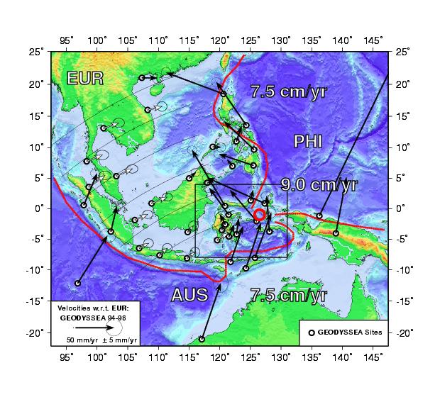 |
| From the tectonic studies developed within GIAC project, and the Geodesy developed within GEODYSSEA, the Sagaing fault appears as a major geologicaly active strike slip fault. The expected rate of slip on this fault is in between 1.5 cm/yr (near field or on the fault trace, in the South) and 3.5 cm/yr (far field or large scale total motion, in the north), which makes it comparable, as far as earthquake potential is concerned, to the major active strike slip faults on Earth like the San Andreas or the North Anatolian fault. Moreover it seems that all the deformation is not localized on the Sagaing fault itself and numerous potentially active faults have been mapped aside from the fault. Large historical earthquakes (magnitudes ~7) are known in the area. In particular the 1839 earthquake appears to have been a major event that destroyed a lot of buildings in the area. Other large earthquakes are known in the area (fig. 2) and the installation of 2 seismological stations in 1997 within the GIAC project revealed a strong microseismic activity associated with the fault zone. |  |
| To have a good knowledge of the seismic activity around the Sagaing fault zone is essential to better understand where and how the crust is deforming and to make progress in the estimation of the seismic potential for this area. This necessitates detailed geodetic surveying already initiated within GIAC (GPS Mandalay network), as well as seismological studies. The location of the city of Mandalay ~ 10 km away from the fault trace should be a strong motivation for developing seismological studies in the area. | 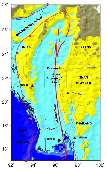 |
Mixing GPS and Seismicity measurements is the best way to monitor an active fault, with potential seismic hasards :
The GPS measurements allow to determinate both the far field and the near field displacements. The velocity field pattern shows where the fault is locked (no surface motion in a narrow strip bounding the fault trace), and where it is not (continuous motion on each side of the fault).
The seismicity measurements allow to determine whether the motion along the fault is silent, more realistically low seismic noise, (creep) or not. More important, they allow to map the seismic gap areas where seismic hasard is at its highest level if the fault is locked on this same area.
unactive segments : old fault traces, no present day deformation on this structure
Creeping segments : continuous a-seismic (or low noise) motion. A great number of small earthquake (magnitude less than 3) accomodate the deformation on the fault.
locked segments : no motion on the fault trace (but deformation accumulated around), no small earthquakes.
Situations 1 and 2 create no danger, situation 3 creates a high potential for a seismic event, which magnitude depends on the far field velocity (inferred by GPS) and on the surface of the rupture zone (inferred from seismicity measurements).
While the San Andreas fault has been studied extensively for decades, we know very little on the Sagaing fault as far as present day tectonics and seismicity are concerned. The combination of GPS and seismicity measurements proposed within this project should enable us to asses more precisely the seimic hasards around the fault.
Appart from the permanent seismic network, most of the goals defined in the project can be achieved within 4 years which is then the time span defined for this project.
Given the present day situation, advancement of operations, time needed to refine cost estimations and contract redaction, we sugest that the project could start in year 2000, alternatively in year 2001 depending on partners availability.
2 Proposals for measurements
2.1 Geodetical (GPS) measurements
Very precise positionning is such a powerful tool that there are plenty of different kind of measurements which could be conducted using GPS. Among them, we identify three different geodetic activities valuable to the project.
2.1.1 Reocupation of the old triangulation network
During the reconnoissance and installation field mission conducted within the GIAC project, it was discovered that an old triangulation network existed in the Mandalay area. If the classical geodetic type measurements are still accessible (angle and distance measurements), it is possible to recompute the position of these pillars back in time with a reasonnable accuracy. Such experiences were conducted on the hold french triangulation networks and proved feasable. In such case, it would be very profitable to re-occupy the still existing pillars by modern means (GPS) to infer their present day positions. given the millimitric accuracy of todays methods, and the very long time span elapsed since the first classical measurements (more than 50 years), rates up to a couple of cm/yr could be easely detected. Such a work requires very little effort, since the old geodetic pillars could be surveyed by GPS very easely, during and/or following the GPS network survey. the only serious requirements are :
Another interesting possibility is be to take advantage of the existing railway track (from Monywa to Pin Oo Lwyn) to measure a topographic profile across the Fault at the latitude of the main transect. Such a profile can be measured very easely and accurately by GPS kinematic methods. One receiver is hold fixed at a reference point (eg. Mandalay Polo ground) and a mobile receiver can be set up on the roof of a railway car. Measuring frequently the position of both receivers (eg. every second), one can reconstruct the trajectory of the mobile with respect to the fixed one, with a centimetric accuracy. From this trajectory one can extract the profile (alitude vs. position), usefull for tectonic interpretation of the area. As a bypass product, we would obtain the railway track path with the same centimetric accuracy, which could even be used in case of an earthquake in the area to measure the deformation pattern (if the track is not too much damaged).
Again, such a work requires very little effort, since those kinematic measurements require only 2 geodetic type GPS receivers for one day during and/or following the GPS network survey. the only need is an authorization to use the roof of a railway car during one journey from Monywa to Pyn Oo Lwyn.
2.1.3 Remeasurements and densification of the new GPS network
The installation and first measurements of a GPS network in Myanmar were already initiated within the GIAC project. A local network was installed in the Mandalay area. This local network will be tied to the main GEODYSSEA network (4 points in Myanmar), in order to be able to analyze local displacements in the frame of the large scale plate tectonics. This local network is made of three transects across the Sagaing fault at the latitude of Mandalay. One long transect (10 points, 150 km) sample the deformation in between the 2 north points of the GEODYSSEA network. Two shorter transects (4 points, 60 km each) sample the deformation 30 km North and South of the main transect. The displacements between points from one given transect will allow to localize the position and constrain the locking depth of the active fault. The displacements between points along the fault will allow to detect active segments of the fault and measure co-seismic motions, in case of an Earthquake in this area of the fault.
The measurements on those networks should be continued within this new project. It is also expected that new measurements bringing new information, extension and densification of the networks will be needed in the future. Successfull results in the Mandalay area should also promote works in different areas of the country. Especially, in the light of upcoming results on the most southern part of the fault (on-shore and of-shore studies), it looks like the situation there is quite different from what it is further North. In the Yangoon area, the deformation happears to be much more diffused than in the Mandalay area, and located further East (on the Pingu fault ?). At sea the situation looks even more complex, the deformation being diffused on a much wider zone. Therefore, the installation of an other GPS network in the Yangoon area could be considered within this project.
2.2 Seismological measurements
Two independent but somewhat complementary studies may be proposed.
2.2.1 Temporary local network
The first and simplest thing of interest which can be done is the installation of a temporary network of about 30 stations covering an area 60x60 km (around Mandalay) for a period of 2 months.
The goal here is a detailed mapping of the seismicity, depth distribution, fault plane solutions and comparison with the geometry of active faults mapped at the surface. The target area will be part of the area covered by GPS measurements. Such an experiment would be useful for interpreting GPS measurements around the Sagaing fault and assess where and how the crust is presently deforming. However, limited in time and space, this experiment will only provide a partial view of the seismic activity associated to the fault zone.
2.2.2 Permanent regional network
The second, and more complicated thing of interest which can be done is the installation of a permanent network of about 10 stations covering an area about 150x100km centered on Mandalay.
The goal here is to be able to record and precisely locate the background seismicity (magnitudes larger than 3). This will give, at the regional scale and on a long term basis, an image of where deformation is occurring and stresses are accumulating. The permanent character of the stations is important to insure homogeneity and continuity of the recordings and be able to construct a reliable catalogue of earthquakes like in any other country where seismic activity is important. Such a catalogue is the basis for further studies concerning the seismic risk in the area.
2.3 Other types of measurements
Of course, all types of other geophysical techniques such as SAR interferometry, seismic profiling, microgravity measurements and seismotectonic studies such as fault characterization, trenching for paleoseismicity, would be extremely valuable additions to the project.
3 Means required and minimum costs estimation
3.1 Geodesy
For all geodetic works, GPS receivers can be provided by the french pool of stations.
3.1.1 Reocupation of old triangulation network
This task implies planning and organization more than costly work. Once a continuously operating site is set up in Mandalay (at the existing location of MDPG), and looked after by a logistic assistant, one team (Myanmar and french scientists) can occupy and measure the old pillars one after the other, for 24 hours session each. The total duration of the mission depends on the actual number of recovered pillars, their location and their accessibility. 2 to 3 weeks seems reasonnable to allow remeasurement of about 10 to 20 ancient sites.
| Cost of shipping the equipment from France (3 receivers) | 10 kF |
| Travel expenses to Yangon for 1 french scientist | 10 kF |
| Local expenses (logistics, Myanmar scientists, ...) | ? |
| Sub Total for old triangulation network | 20 kF |
This part can be done basically at no specific cost for the french partners. Such a profile can be done during or immediately after the remeasurement of the local GPS Mandalay network, taking advantage of the presence of the logistic, receivers, etc...
3.1.3 Remeasurements and densification of the new GPS network
Cost estimations for this part can rely on previous estimates made in the frame of the geodetic extension to the GIAC contract under which initial measurements of this network were conducted (5 teams, 3 weeks). Only marginal costs for additionnal installations should be considered (drill, markers, concrete monumets when needed, etc...).
The installation and measurement of a new network in the Yangoon area could also be included at marginal cost, only the time span for the field mission would have to be longer (5 to 10 days more).
| Cost of shipping the equipment from France | 20 kF |
| Travel expenses to Yangon for 5 french scientists | 40 kF |
| Equipment and consumable for new sites installation | 10 kF |
| Data storage and processing | 10 kF |
| Local expenses (logistics, Myanmar scientists, ...) | ? |
| Sub Total for remeasurement of GPS network (once) | 80 kF |
| Sub Total for remeasurement of GPS network (3 times over the duration of GIAC2) | 240 kF |
The seismological stations may be provided by the french national pool of stations. For the installation of the network, 3 teams are necessary for a period of 10 days. Each team should be composed of one French scientist, one Myanmar scientist and one logistic assistant and have a car. The maintenance of the network will be performed by 2 teams, each of them having a car at its disposal.
| Cost of shipping the equipment from France | 60 kF |
| Travel expenses to Yangon for 5 french scientists | 40 kF |
| Data storage and processing | 50 kF |
| Local expenses (logistics, Myanmar scientists, ...) | ? |
| Sub Total for local temporary network | 150 kF |
This is a long term project (at least 10 years in order to obtain significant results) that requires investments both in terms of budget and people. The success of such a project in the long term will be extremely valuable if Myanmar scientists from universities or public organisms are involved from the start. It also implies that some scientists from Myanmar be trained in French Institutes. One permanent Myanmar institution should be identified and responsible for the maintenance and data storage.
| Equipment purchase | |
| For each station | |
| one 3 components seismometer | 20 kF |
| one seismological station with GPS receiver for time | 50 kF |
| solar panels, baterries... | 10 kF |
| sub total per station | 80 kF |
| Sub Total for equipment of 10 stations | 800 kF |
| Cost of shipping + travel expenses for French scientists | 150 kF |
| Central computer with disk space and data storage | 100 kF |
| Local expenses (logistics, Myanmar scientists, ...) | ? |
| Sub Total for installation and starting | 250 kF |
| Maintainance of equipment (50 kF/year x10) | 500 kF |
| Computer consumables (25 kF/year x10) | 250 kF |
| Local expenses (logistics, Myanmar scientists, ...) | ? |
| Sub Total for 3 years of operations (duration of GIAC2 contract) | 300 kF |
| Sub Total for 10 years of operations | 750 kF |
| Sub Total for permanent regional network (over duration of GIAC2 contract: 3yr) | 1275 kF |
| Sub Total for permanent regional network (over 10 years) | 1800 kF |
| Meetings in Myanmar (one mid-contract, one end of contract) | ? |
| Travel for meetings (for 2-3 French scientists, twice over duration of GIAC2 contract) | 40 kF |
| Myanmar students training at ENS laboratory | ? |
| Administration costs | 60 kF |
| Sub Total for other expenses (over duration of GIAC2 contract: 4yr) | 100 kF |
Again note that at this point of the proposal, only French expenditures (equipment, computing time, travel, etc...) are precisely computed. All costs related to Myanmar partners and local operations (field trips, logistics, etc...) should be computed and added to this estimation.
| 3.1.1 Old triangulation network | 20 kF | |
| 3.1.2 Kinematic profile across the Sagaing fault | 0 kF | |
| 3.1.3 Remeasurement of GPS network (3 times over the duration of GIAC2) | 240 kF | |
| 3.2.1 Seismic local temporary network | 150 kF | |
| 3.2.2 Seismic permanent regional network | (over duration of GIAC2 contract: 3yr) | 1275 kF |
| (over 10 years) | 1800 kF | |
| 3.3 Meetings, travel, student training, administration and other expenses | 100 kF | |
| Total Budget | (over duration of GIAC2 contract: 4yr) | 1785 kF |
| (over 10 years) | 2310 kF | |
| YEAR 1 | YEAR 2 | YEAR 3 | YEAR 4 | |||||||||||||||||||||||||||||||||||||||||||||
| 1 | 2 | 3 | 4 | 5 | 6 | 7 | 8 | 9 | 10 | 11 | 12 | 1 | 2 | 3 | 4 | 5 | 6 | 7 | 8 | 9 | 10 | 11 | 12 | 1 | 2 | 3 | 4 | 5 | 6 | 7 | 8 | 9 | 10 | 11 | 12 | 1 | 2 | 3 | 4 | 5 | 6 | 7 | 8 | 9 | 10 | 11 | 12 | |
| Investigations on existing old triangulation networ (pillars and measurements) | ||||||||||||||||||||||||||||||||||||||||||||||||
| GPS measurements on old triangulation network | ||||||||||||||||||||||||||||||||||||||||||||||||
| Remeasurements of new Myanmar GPS networks (regional and local) | ||||||||||||||||||||||||||||||||||||||||||||||||
| GPS Data Analysis (lab. computer work) | ||||||||||||||||||||||||||||||||||||||||||||||||
| Seismological local and temporary campaign | ||||||||||||||||||||||||||||||||||||||||||||||||
| Seismic Data analysis (lab. computer work) | ||||||||||||||||||||||||||||||||||||||||||||||||
| Seismological permanent and regional network recon. Equipment purchase, procedure definitions, etc... | ||||||||||||||||||||||||||||||||||||||||||||||||
| Permanent seismic network operations | ||||||||||||||||||||||||||||||||||||||||||||||||
| Reporting | ||||||||||||||||||||||||||||||||||||||||||||||||
| Student Activity | ||||||||||||||||||||||||||||||||||||||||||||||||
| FINANCIAL COMMITMENTS | OTHER COMMITMENTS | ||||
| kFF | kUSD | Activity | |||
| ENS | Year 1 | 0 | 0 | Seismic and GPS meas. | 3 to 4 senior scientists |
| Year 2 | 0 | 0 | GPS campaigns Seismic and GPS data analysis | 1 to 2 post-docs | |
| Year 3 | 0 | 0 | GPS campaigns Seismic and GPS data analysis | 1 student full time | |
| Year 4 | 0 | 0 | GPS campaigns Seismic and GPS data analysis | ||
| TOTAL | 0 | 0 | Scientific facilities available over the whole working period (computer, analyses, etc...) | ||
| TMEP | Year 1 | 20 | 3.6 | GPS old net. remeasurement | Assistance to ENS scientists in Myanmar :
|
| 150 | 26.8 | Seismic first campaign | |||
| 800 | 142.9 | Equipment for permanent seismic network | |||
| ? | ? | Logistics | |||
| 35 | 6.3 | Administration costs | |||
| 1005 | 179.6 | ||||
| Year 2 | 80 | 14.3 | GPS measurements | ||
| 250 | 44.6 | Permanent Seismic Network Installation | |||
| 75 | 13.4 | Permanent Seismic Network Operation | |||
| 20 | 3.6 | Half Term Meeting | |||
| ? | ? | Logistics | |||
| 15 | 2.7 | Administration costs | |||
| 440 | 78.6 | ||||
| Year 3 | 80 | 14.3 | GPS measurements | ||
| 75 | 13.4 | Permanent Seismic Network Operation | |||
| ? | ? | Logistics | |||
| 5 | 0.9 | Administration costs | |||
| 160 | 28.6 | ||||
| Year 4 | 80 | 14.3 | GPS measurements | ||
| 75 | 13.4 | Permanent Seismic Network Operation | |||
| 20 | 3.6 | Terminal Meeting | |||
| ? | ? | Logistics | |||
| 5 | 0.9 | Administration costs | |||
| 180 | 32.2 | ||||
| TOTAL | 1785 | 319 | |||
Should the present proposal be accepted by TMEP, the following points could be included in the final contract (following GIAC guidelines) :
ENS will be responsible for the realisation of the project. Professor Xavier Le Pichon, director of the "laboratoire de géologie" will act as the overall coordinator.
The scientific results of the project will be provided by ENS to TMEP, including MOGE and involved Myanmar universities, under the same conditions as in the GIAC project. (GIAC project: article 9 : data property). Final results will consist in :
2.1 GPS : station positions and velocities.
2.2 Seismology : seismic events localization and focal mechanism determination Complete digital data sets willl be provided by ENS to all participating institutions.
Progress reports will be provided, under the same conditions as in the GIAC project, after completion of the following phases of the program :
3.1 after each round of GPS measurements
3.2 after the completion of the temporary local seismic campaign
3.3 after the installation of the permanent seismic network
3.4 after every year of operation of the permanent seismic network
Involved ENS personnel will observe the contractual dispositions of the GIAC project, including environmental, security, and other issues as defined in the GIAC project article 12.