On January 28, 2020, a shallow Mw7.8 earthquake struck the boundary between the Caribbean and North American plates in the Cuba-Jamaica area. The earthquake likely ruptured the Oriente fault, a major left-lateral strike-slip fault that separates the shallow Cayman Ridge to the north from the detp (5000-7000 m) Cayman Through to the south.
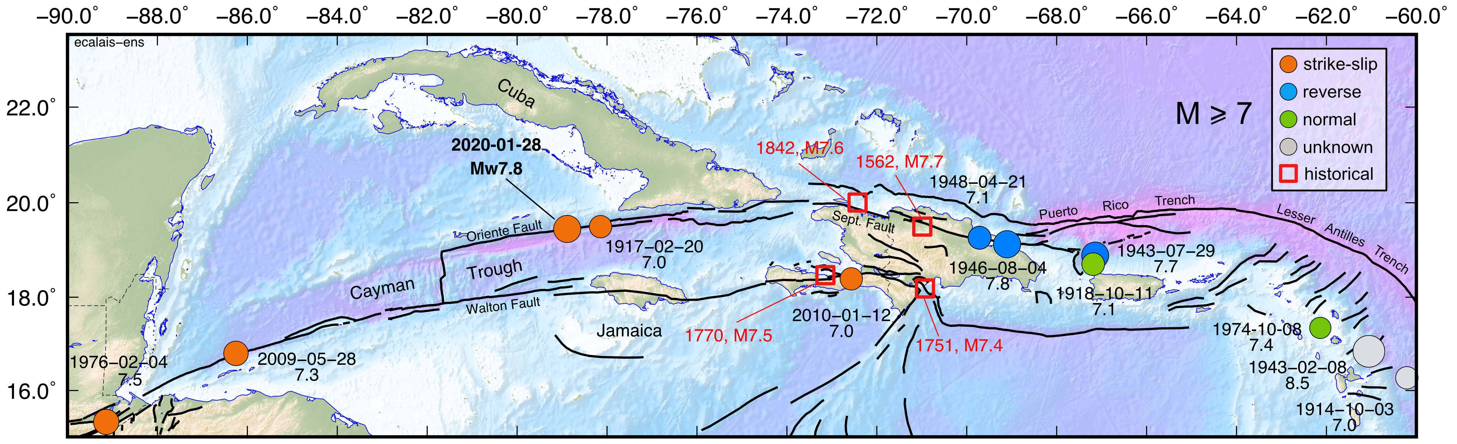
Compilation of earthquakes with magnitude greater than or equal to 7 along the northern Caribbean plate boundary. Sources used: ISG GEM catalog (2019), tenBrink et al. (2011), Bakun et al. (2012), Stein et al. (1982), Doser et al. (2005), Hough (2013).
This earthquake is the largest strike-slip event of the instrumental seismology era along the northern Caribbean plate boundary, ranking right after the Ms7.5 event that struck Guatemala on February 4th 1976 along the Motagua fault section of the plate boundary (Plafker, 1976). Historical events with similar magnitude and (likely) source mechanism have been described further east along the same fault system in 1842 in northern Haiti and 1562 in the northern Dominican Republic (Scherer, 1912; ten Brink et al., 2011).
Although the January 28, 2020, Cayman Trough earthquake was widely felt in the region — there were reports of shaking all the way to Florida — it fortunately caused limited damage. No fatalities were reported, only a few poorly-built houses where affected in the Granma province of Cuba. Had this earthquake occurred further east along the more populated segments of the Oriente-Septentrional fault system, damage and fatalities could have been very significant.
Coseismic displacements
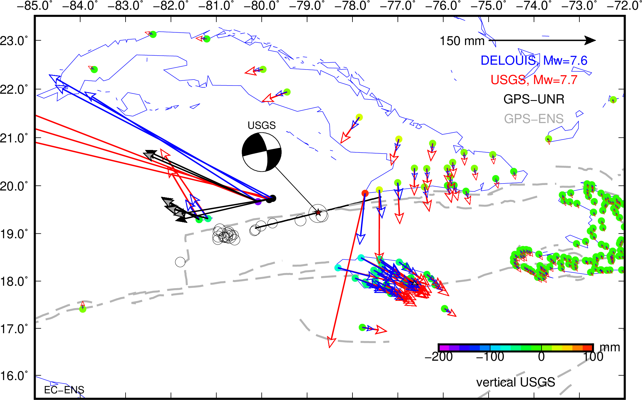
The map above shows the coseismic displacements (1) predicted by two finite fault models (G. Hayes @USGS and B. Delouis @Géoazur), and (2) measured at continuous GPS stations (U. Nevada Geodetic lab and our work). Model displacements are shown at all continuous and campaign GPS sites in the region, measured one are shown at 5 regional continuous GPS stations (Cayman islands and Jamaica). Position time series at these continuous GPS sites are available here:
- Daily positions at regional continuous GPS sites, calculated using Gamit/Globk with rapid orbits.
- Kinematic positions for the day of the earthquake, calculated using Track with rapid orbits.
Coseismic offsets at 34 regional continuous GPS sites are provided in this file (psvelo format, last 2 columns are vertical).
Seismic recordings
This earthquake was well-recorded, in particular, by RaspberryShake seismic stations installed in Haiti in the framework of the S2RHAI project. This citizen science project aims at using cheap (but efficient) seismic stations hosted by individuals in order to establish a dialog with the civil society, improve our ability to provide information when an earthquake strikes, and eventually raise general interest in seismic risk reduction in Haiti.
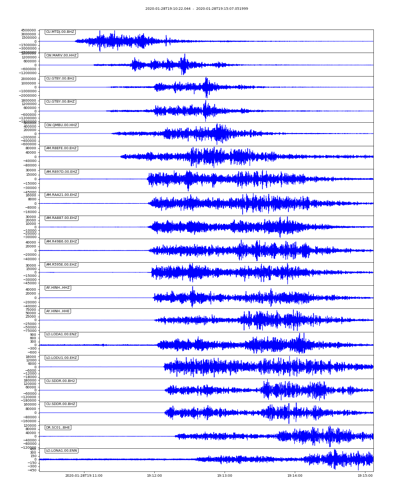
Real-time seismicity in Haiti and surroundings is provided by Ayiti-Séisme, a web interface developped as part of the S2RHAI project. The January 28, 2020, earthquake can be found here. See below a map view of the event and the stations that recorded it, as well as a display of the seismic records ordered as a function of distance to the source.
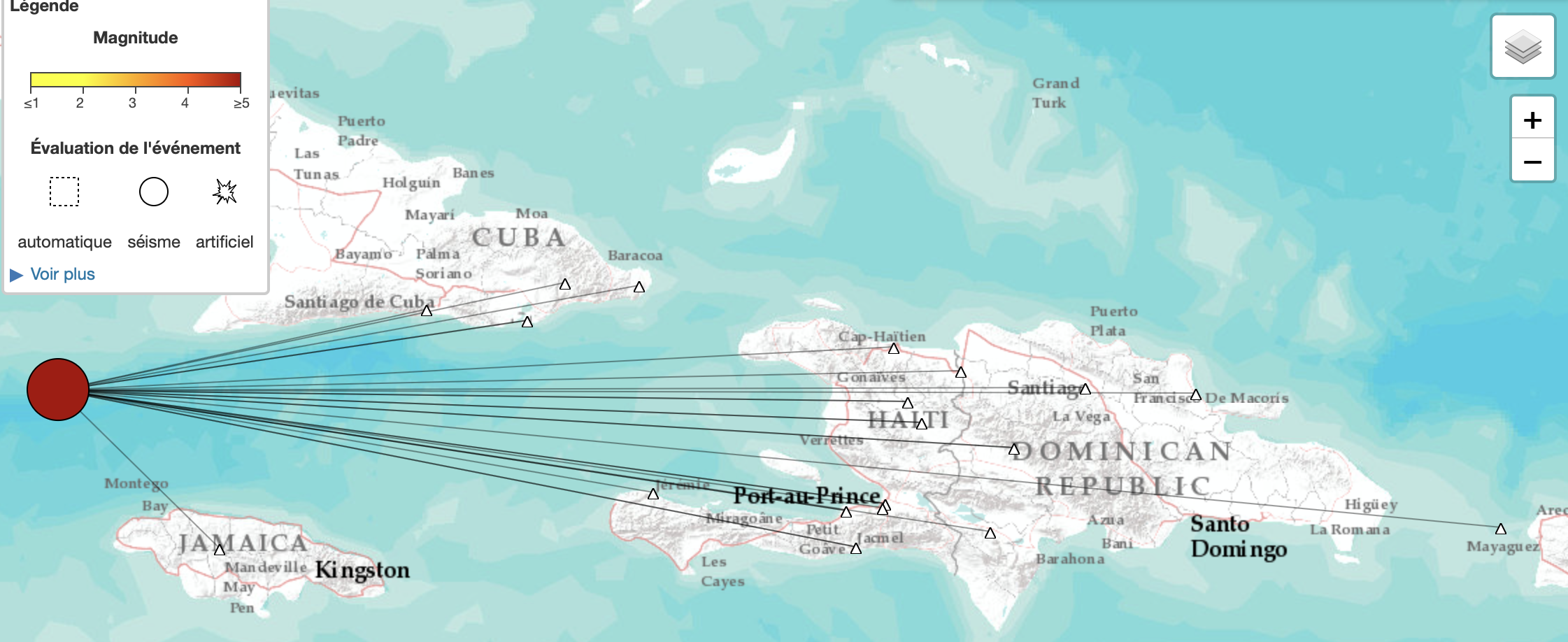
The earthquake was recorded at 6 of the RaspberryShake seismic stations operational in Haiti, named “AM_” in the plot below. Of course, this large earthquake was also recorded at many seismic stations globally, at distances up to 17,000 km from the epicenter, as shown on the Geoscope or USGS event pages.
Context
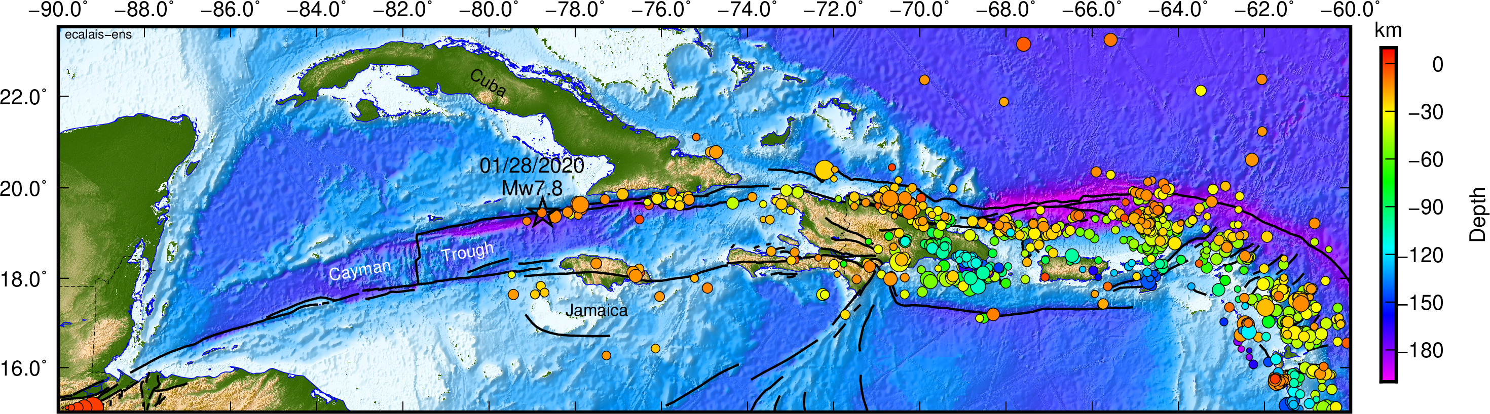
Tectonic context of the 01/28/2020 earthquake. The epicenter is shown with a black star. Colored circles show the location of M>3 earthquakes in the region from the Engdahl database, color-coded as a function of depth. Black lines show major active faults.
The January 28 Cayman Trough earthquake occurred along the boundary between the North American and Caribbean plates. Its moment magnitude is calculated at 7.8 by Géoscope and at 7.7 by the USGS. The event very likely ruptured the Oriente fault, the major vertical left-lateral strike-slip fault that bounds the Cayman Trough to the north. The figure below shows that the rupture filled a segment of the fault devoid of significant events for at least the past ~100 years.
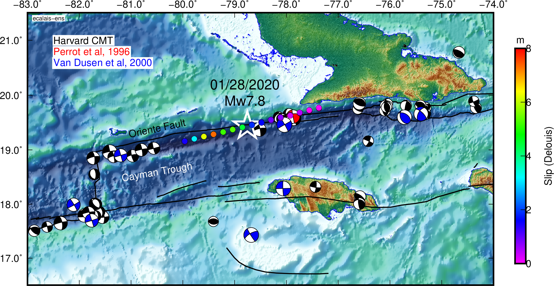
Compilation of earthquake focal mechanisms along the eastern Cayman Trough segment of the Caribbean-North America plate boundary. Black: Harvard CMT database (1977 to Present), blue: historical earthquakes (1917 to 1962) from Van Dusen and Doser, 2000, red: 1992, Ms=6.9, Cabo Cruz earthquake (Perrot et al, 1996). Colored circles show the coseismic slip as estimated by B. Delouis (@Géoazur).
This event is similar in magnitude to two large historical earthquakes that likely ruptured the eastward continuation of the Oriente fault in Hispaniola, where it is called the “Septrentrional fault”. ten Brink et al. (2011) quote a December 2, 1562, event in the Cibao valley of the Dominican Republic at MI7.7, and the May 7, 1842, event of northern Haiti at MI=7.6 (intensity magnitudes). It is much larger than the three largest known earthquakes that struck southern Cuba in 1766, 1952, and 1932, with magnitudes of 6.8, 6.4, and 6.75, respectively (Cotilla and Cordoba, 2010) — although previous authors proposed larger magnitudes (M7.5 and M7.3 for the 1766 and 1852 events, respectively, according to Alvarez et al., 2001).
Recent kinematic models of the northern Caribbean plate boundary derived from GPS measurements show that the Caribbean — North America plate motion in this region involves the additional Gonave microplate, as proposed by Mann et al. (1995) and demonstrated by DeMets et al. (2007) and Benford et al. (2012).
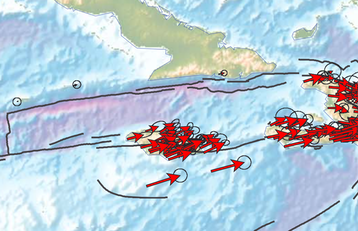
From Symithe et al. (2015): GPS velocities shown with respect to the North American plate. Arrows to the south of Jamaica are ~20 mm/yr. One can see that the Caribbean — North America plate motion is taken up by both the Oriente fault along the southern Cuban margin and the Walton/Enriquillo Plantain Garden fault zone through Jamaica.
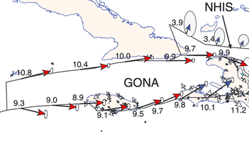
From Symithe et al. (2015): predicted slip rates along the Oriente (~10 mm/yr) and Walton/Enriquillo Plantain Garden (~9-10 mm/yr) faults derived from a kinematic model based on GPS measurements. GONA indicates the Gonave microplate, bounded to the north by the Oriente fault and to the south by the Walton/Enriquillo Plantain Garden fault zone.
Source mechanisms
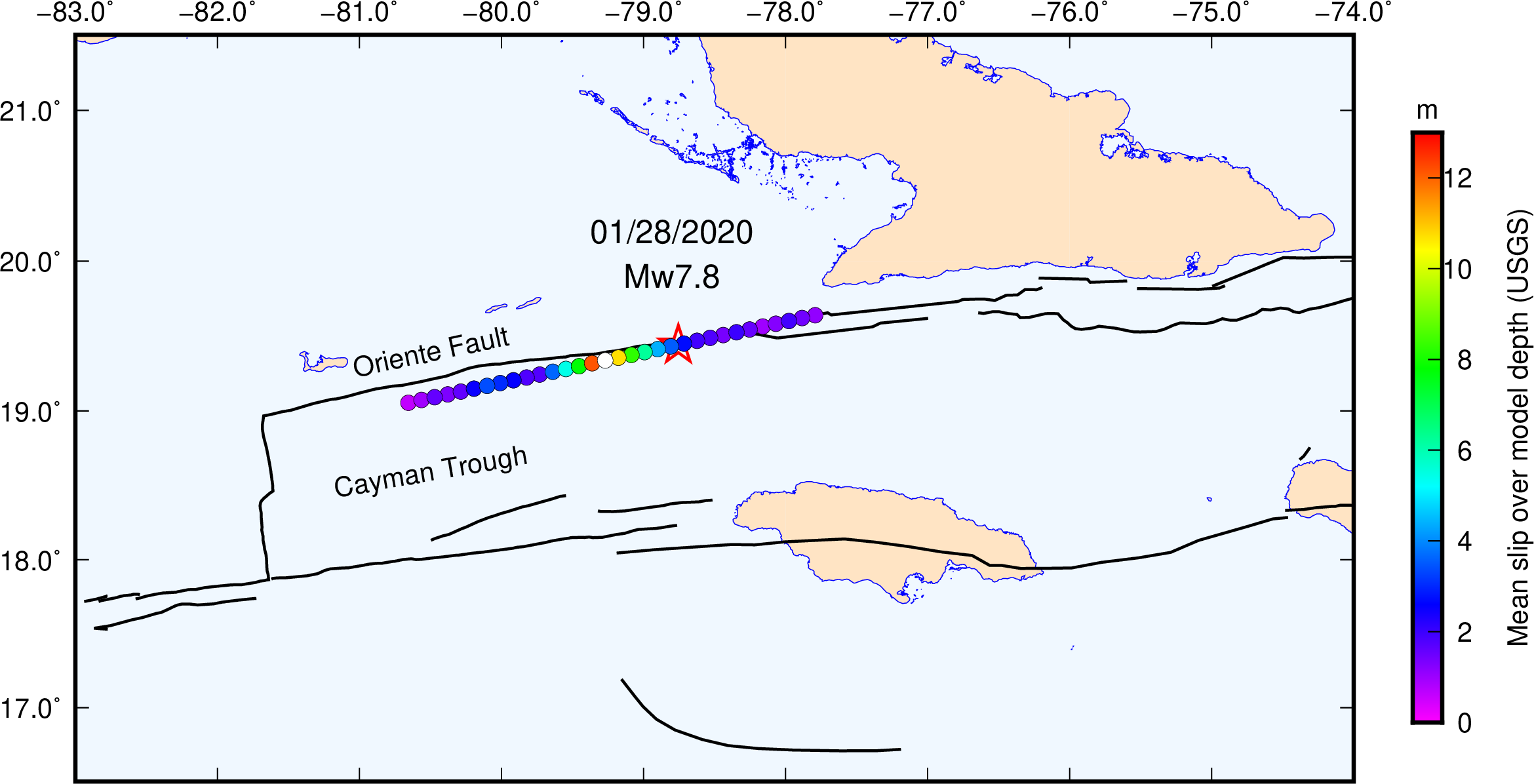
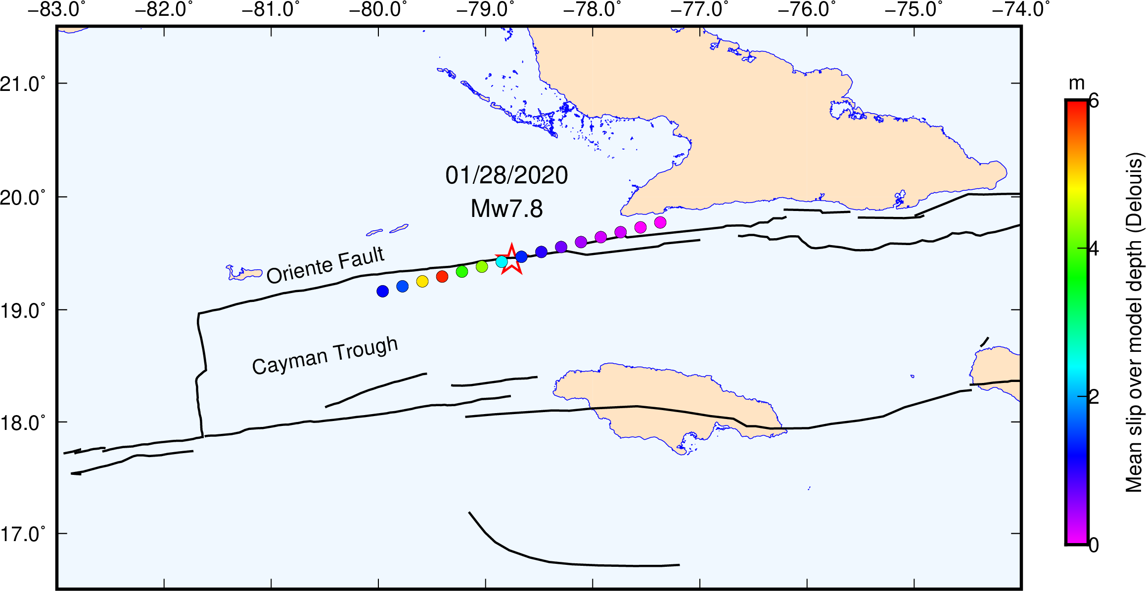
Two finite source models have been published so far by G. Hayes @USGS (top figure below) and by B. Delouis @Géoazur (bottom figure below). WARNING: the origin of the distance axis is different on both plots, as well as the color scale. The arrow directions show the rake for each patch, indicative of largely strike-slip faulting event with a small component of normal faulting. Slip in the USGS model is more than twice larger than in Delouis’ model.
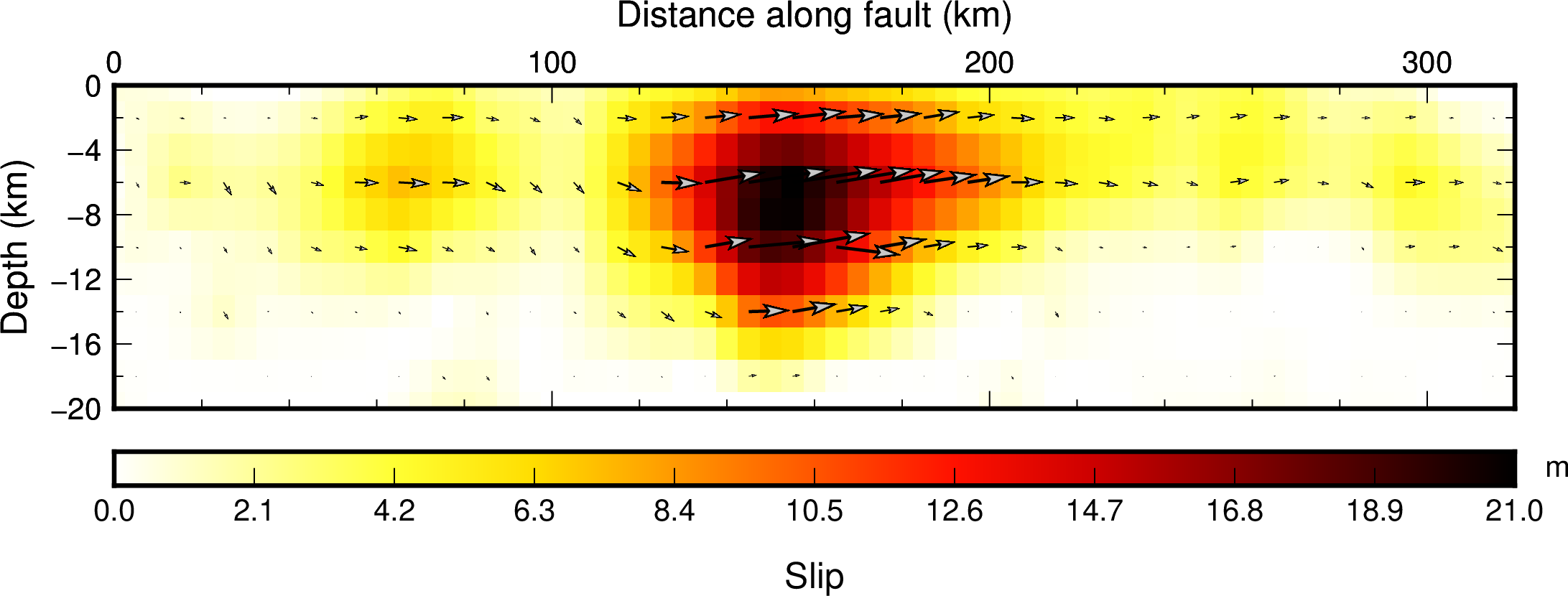
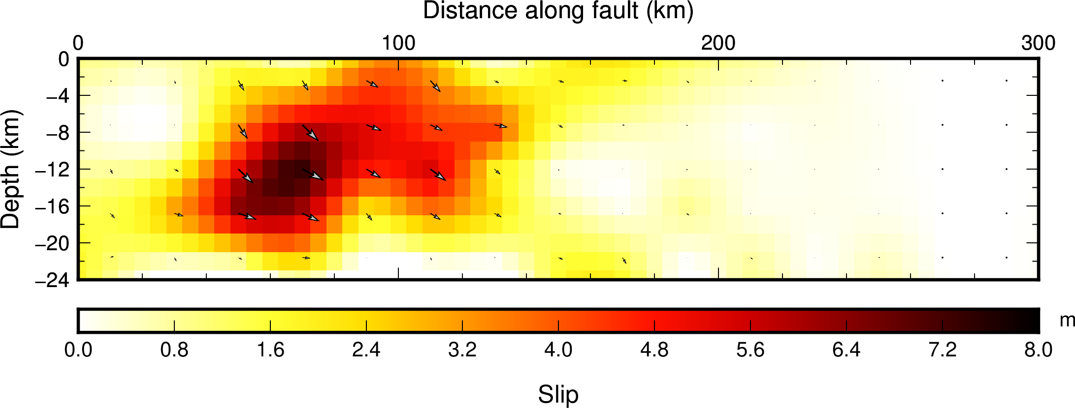
It is useful to compare the two models in map view, where the mean slip over the depth of the model is plotted along the rupture. One can see that the fault geometries are similar. Both models detect a large area of slip to the west of the epicenter, along a segment of the Oriente fault that is devoid of significant events for at least the past ~100 years (see above).
Next steps
As of February 10, 2020: in collaboration with researchers from Cuba, USA, and Jamaica, we are planning to (1) remeasure existing GPS campaign sites in Cuba and Jamaica to determine coseismic displacements, (2) process data from additional contonuous GPS sites in Cuba and Jamaica to determine coseismic displacements, and (3) include static GPS coseismic displacements, together with waveforms from seismic stations in Cuba and Jamaica, in order to better determine the source mechanism. Other developments are envisioned that we shall describe later on.
Other resources
- USGS Earthquake Hazards Program
- Geoscope @IPG Paris
- Univ. Nevada Geodesy Lab
- UNAVCO
- And of course Wikipedia…
Acknowledgments
This research is carried out as part of the PREST project, funded by the INTERREG CARAIBE program of the European Union, in collaboration with the Centro Nacional de Investigaciones Sismological (CENAIS) in Cuba, the Geoazur laboratory of the University Cote d’Azur (Nice, France), and the GET laboratory in Toulouse, France. Many of the continous GPS stations are part of the COCONet project, now incorporated into the Network of the Americas, operated by UNAVCO. We are grateful to the CNRS-INSU GNNS pool for lending us GPS equipment.