GLOBAL GEODYSSEA GPS NETWORK
| ID# | FULL NAME | COUNTRY | LATITUDE | LONGITUDE |
| 01 | Andaman Is. | India | 12 36 | 92 42 |
| 02 | Nicobar Is. | India | 07 06 | 93 54 |
| 03 | Chonburi | Thailand | 13 43 | 100 27 |
| 04 | Phuket Is. | Thailand | 07 52 | 98 22 |
| 05 | Da Lat | Vietnam | 11 56 | 108 25 |
| 06 | Hanoi | Vietnam | 21 01 | 105 52 |
| 07 | Brunei | Brunei | 04 56 | 114 58 |
| 08 | Batan Is. | Philippines | 20 49 | 121 54 |
| 09 | Subic, Zemales Is. | Philippines | 14 52 | 120 16 |
| 10 | Virac, Catanduanes Is. | Philippines | 13 35 | 124 14 |
| 11 | Iloilo, Panay Is. | Philippines | 10 41 | 122 33 |
| 12 | Puerto Princessa, Palawan Is. | Philippines | 09 46 | 117 45 |
| 13 | Surigao, Mindanao Is. | Philippines | 09 47 | 125 29 |
| 14 | Zamboanga, Mindanao Is. | Philippines | 06 55 | 122 05 |
| 15 | Davao, Mindanao Is. | Philippines | 07 05 | 125 28 |
| 16 | Tawau, Sabah | Malaysia | 04 16 | 117 54 |
| 17 | Kuala Trengganu | Malaysia | 05 20 | 103 07 |
| 18 | Sigli, Sumatra | Indonesia | 05 21 | 95 56 |
| 19 | Pini Is. | Indonesia | 00 05 | 98 40 |
| 20 | Pangkalpinang, Bangka Is. | Indonesia | -02 05 | 106 09 |
| 21 | Enggano Is. | Indonesia | -05 30 | 102 15 |
| 22 | Cibinong, Java | Indonesia | -06 26 | 106 50 |
| 23 | Karang Sambung, Java | Indonesia | -07 21 | 109 56 |
| 24 | Denpasar, Bali | Indonesia | -08 40 | 115 14 |
| 25 | Pontianak, Borneo | Indonesia | -00 05 | 109 16 |
| 26 | Balikpapan, Borneo | Indonesia | -01 15 | 116 50 |
| 27 | Manado, Sulawesi | Indonesia | 01 32 | 124 55 |
| 28 | Tomini, Sulawesi | Indonesia | 00 31 | 120 30 |
| 29 | UjungPandang, Sulawesi | Indonesia | -05 08 | 119 25 |
| 30 | Kendari, Sulawesi | Indonesia | -04 00 | 122 33 |
| 31 | Ternate, Halmahera | Indonesia | 00 48 | 127 23 |
| 32 | Ambon, Ambon Is. | Indonesia | -03 41 | 128 10 |
| 33 | Alor Is. | Indonesia | -08 15 | 124 54 |
| 34 | Ende, Flores | Indonesia | -08 51 | 121 40 |
| 35 | Kupang, Timor | Indonesia | -10 13 | 123 38 |
| 36 | Biak Is., Irian Jaya | Indonesia | -00 53 | 135 57 |
| 37 | Wamena, Irian Jaya | Indonesia | -02 45 | 138 24 |
| 38 | Dobo, Kepulauan Is. | Indonesia | -05 48 | 134 13 |
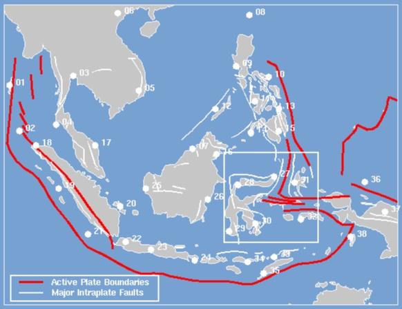
the GEODYSSEA global network as planned in Jakarta, October 1991. Tectonic settings are from Adicott and Richards 1981. (click to enlarge)
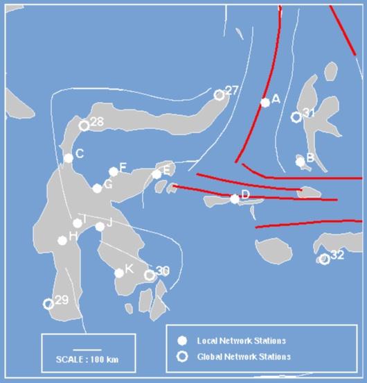
LOCAL SULAWESI GPS NETWORK - additional stations
| NUMBER | FULL NAME | COUNTRY | LATITUDE | LONGITUDE |
| A | Mayu Is. | Sulawesi | 01 20 | 126 22 |
| B | Lapuha, Bacan Is. | Halmahera | -00 35 | 127 29 |
| C | Ampibako | Sulawesi | -00 27 | 120 03 |
| D | Dofa, Mangole Is. | Sulawesi | -01 46 | 125 23 |
| E | Luwuk | Sulawesi | -00 58 | 122 53 |
| F | Ampana | Sulawesi | -00 53 | 121 30 |
| G | Tombo-Yono | Sulawesi | -01 25 | 120 58 |
| H | Makale | Sulawesi | -03 06 | 119 51 |
| I | Masamba | Sulawesi | -02 32 | 120 21 |
| J | Malili | Sulawesi | -02 39 | 121 04 |
| J | Pomala | Sulawesi | -04 09 | 121 41 |