Research
Keywords: Active Faults, Seismic Cycle, Interseismic Deformation, Creep, InSAR, GPS
You will find below a few research topics of my own, including Active Faults, InSAR and Bayesian inference
Current postdocs and PhD students :
Paul Dérand -- PhD Student
Farzaneh Mohammadi -- PhD Student co-advised with Dr. Beaucé (Lamont)
Christian Emmanuel -- PhD Student co-advised with Pr. Calais (ENS)
Bharath Shan -- PhD Student co-advised with Dr. Bhat (ENS/CNRS)
Fares Mokhtari -- PhD Student @Univ Lyon 1 co-advised with Dr. Lasserre (CNRS)
Giuseppe Costantino -- Postdoc
Emile Denise -- Master intern
Angélique Marck -- Master intern
Joel Szrek -- Master intern
Former group members:
Bryan Raimbault -- PhD Student, now Postdoc @JPL
Jorge Jara -- Post-doc (ERC Geo4D), now Marie S. Curie Fellow @GFZ
Manon Dalaison -- Post-doc (ERC Geo4D, former PhD student), now Associate Prof. @IPGP
Sylvain Michel -- Post-doc (CNES/ERC Geo4D), now Post-doc @IRSN
Claudia Hulbert -- PhD Student, 2018 - 2021, now CEO of GeoLabe
Elenora Van Risjingen -- Post-doc (main advisor Pr. E. Calais)
Théo Rebert -- Master Student -- 2019 - 2020
Philippe Danré -- Master Student -- 2018 - 2019
Angélique Benoit -- PhD Student -- 2016 - 2019
ERC Consolidator Grant iQuake :
iQuake starts in September 2024 and is funded by the ERC. Currently seeking for a PhD student. See Opportunities.
ERC Starting Grant Geo4D :
Geo4D is over (2018-2023)
Codes:
A python-based method for Kalman filter time series analysis in InSAR:
KF-TS -- Kalman Filter Time Series
Python tools to handle geodetic data, faults and inverse problems:
CSI -- Classic Slip Inversions
A code for atmospheric corrections of InSAR data using Global Re-Analysis data:
PyAPS -- Python-based Atmospheric Phase Screen (python 2 version)
PyAPS3 -- Python-based Atmospheric Phase Screen (python 3 version + ERA-5 support)
A time series analysis toolbox for InSAR data:
GIAnT -- Generic InSAR Analysis Toolbox
An code to correct unwrapping errors in InSAR:
CorPhU -- Correcting Phase Unwrapping
An Time Series analysis code that deals with all pixels simlutaneously:
MPITS -- Multi-Pixel InSAR Time Series
An Example -- This is the synthetic example used in Jolivet & Simons (2018).
A full python version of the Bayesian sampler we use (GPU version not released yet):
AlTar -- Bayesian Solver for large inverse problems
Active faults, earthquakes, aseismic slip:
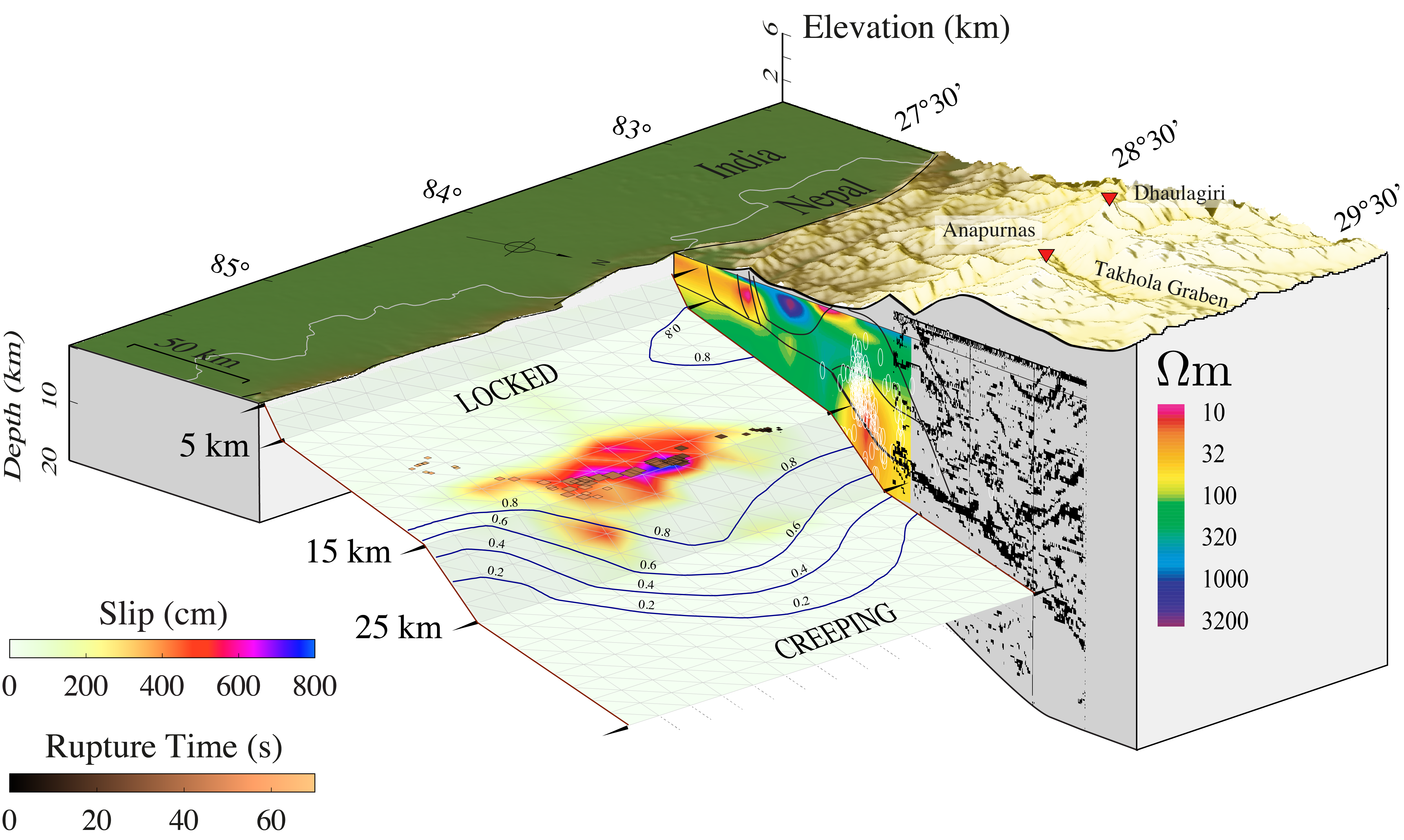
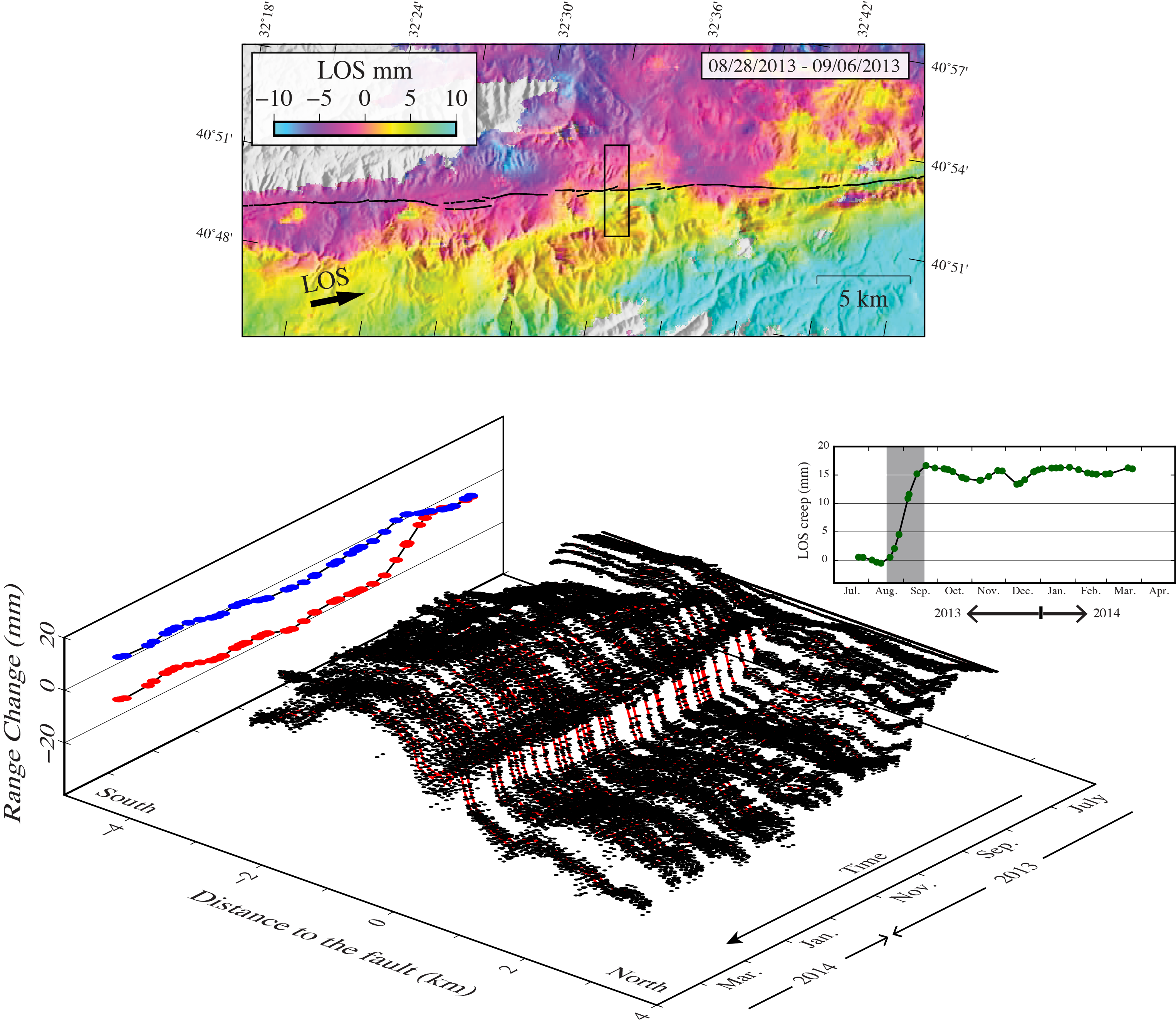
Active faults accomodate the relative motion of tectonic plates. The classic view is that most active faults are locked, accumulating stress and releasing it during earthquakes. Geodetic observations over the last 50 years have shown this picture is oversimplified. Some faults slip aseismically continuously releasing stress. Some faults experiences slow slip events. Some faults see periodic variations of aseismic slip rates. A wide variety of modes of slip have been discovered using triangulation methods, creepmeters, offseted markers and more recently GPS and InSAR data. What are the relationships between slow and rapid slip (i.e. between silent slip and earthquakes)? What is the influence of slow and rapid slip on long term processes? What is (are) the physical model(s) underlying these different modes of slip? I use space-based geodetic methods to capture, characterize and model all styles of fault slip, toward a better understanding of the behavior of active faults.
Slip distribution of the 2015, Mw 7.8, Gorkha earthquake. See Elliott et al. 2016 in the Publications section
Evolution of surface slip across the North Anatolian Fault during a slow slip event. See Rousset et al. 2016 in the Publications section
Interferometric Synthetic Aperture Radar:
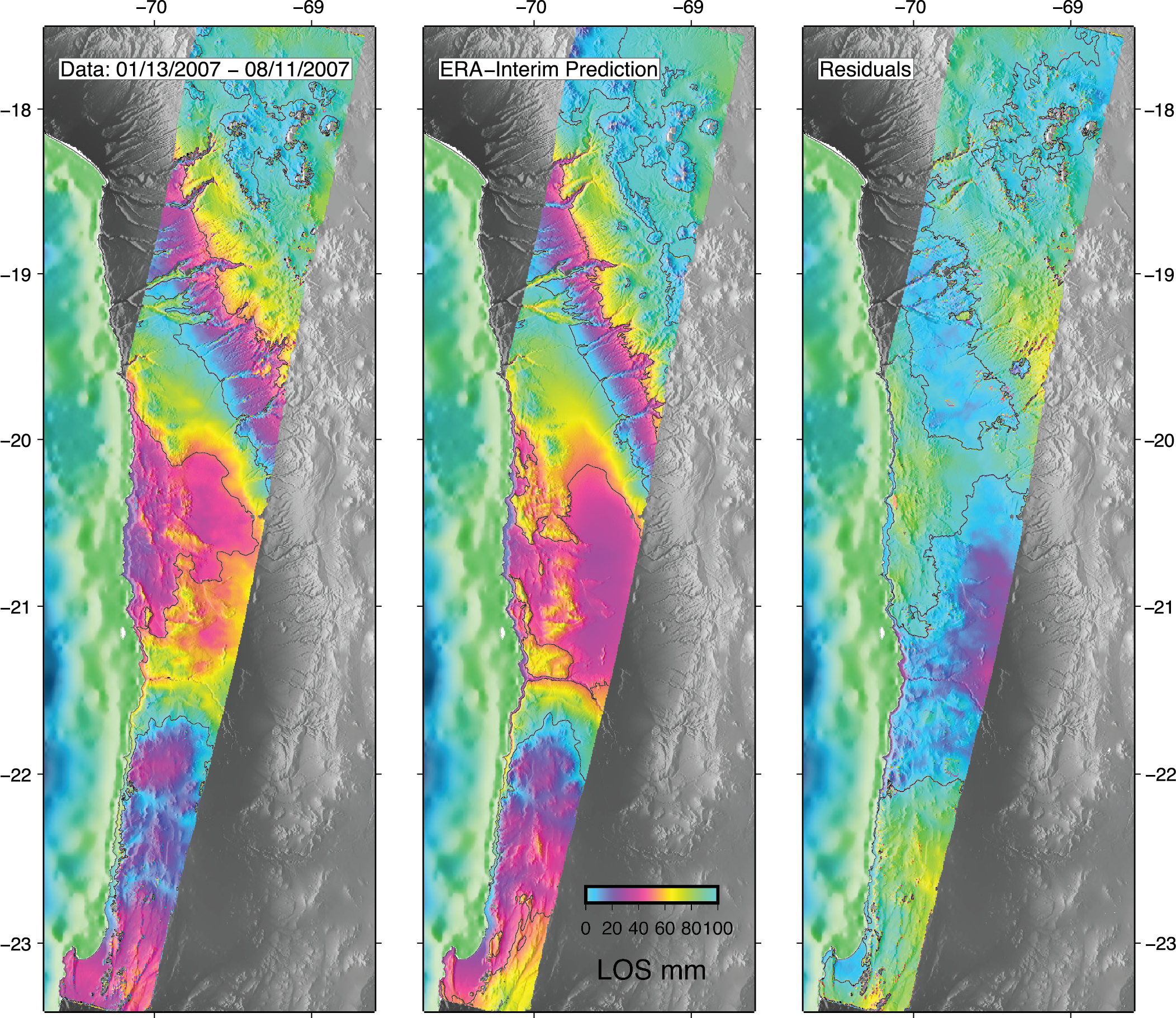
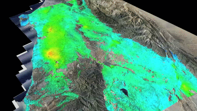
Interferometric Synthetic Aperure Radar is a space-based technique allowing to derive images of ground deformation. This method is based on repeated acquisitions by a Radar system onboard a satellite. The interferogram combining two images of the ground is a function of all sources of change in travel time of the Radar wave through the atmosphere, including deformation and atmospheric variations in temperature, pressure and water vapor. My goal is to derive the best images and time series of images of the deformation of the ground as possible. To do so, I develop new time series analysis methods to reconstruct the history of ground motion from Radar images. I also work on the correction of atmospheric perturbations, modeling atmospheric delays using Global Atmospheric Models.
Prediction of atmospheric delay using the global weather re-analysis ERA-Interim. See Jolivet et al. 2014 in the Publications section
A time series of ground displacements in the Los Angeles basin. See Riel et al. 2014 in the Publications section
Bayesian inverse problems in earth sciences:
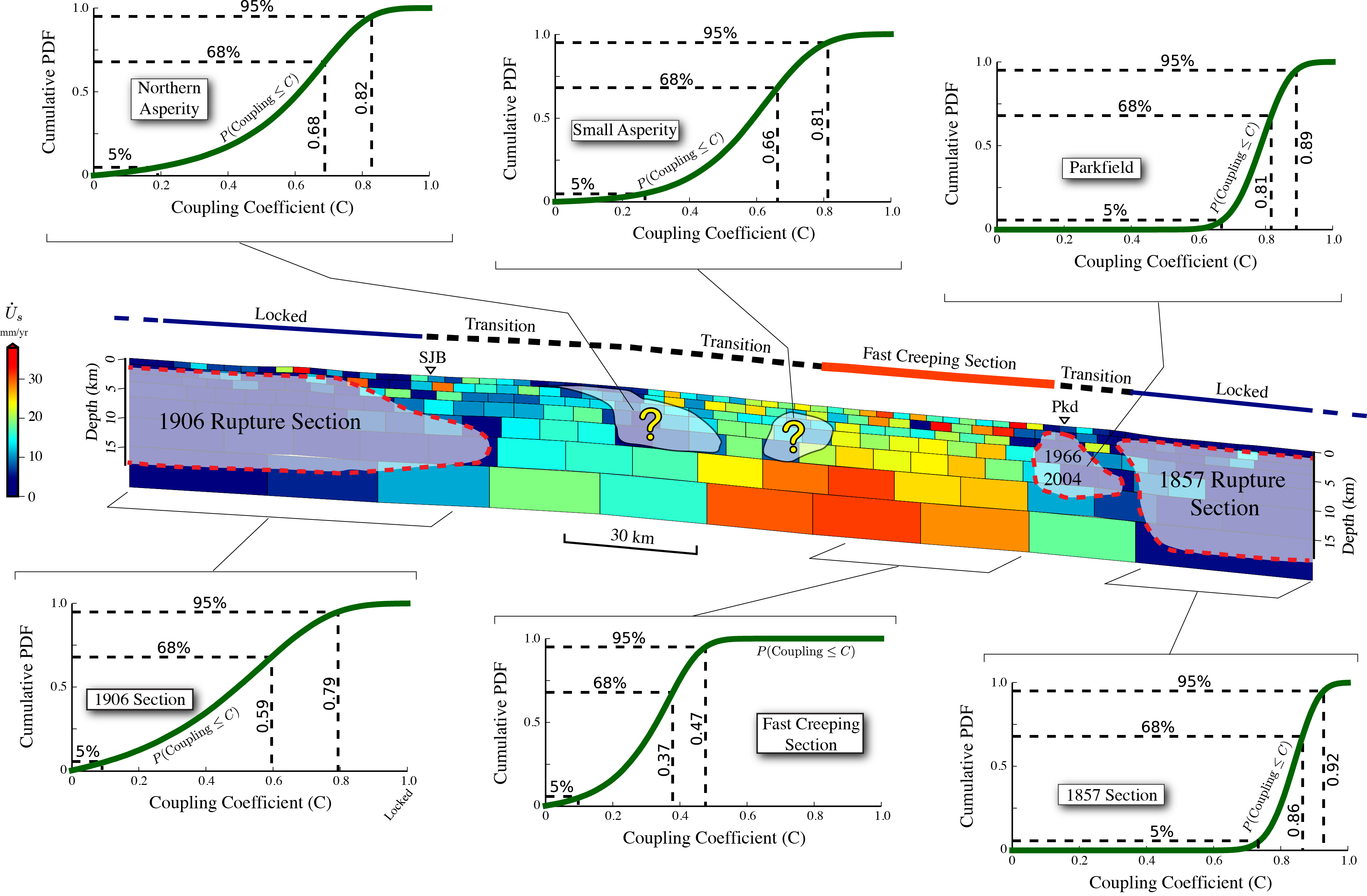
In various fields of Earth Sciences, one needs to extract information from data to constrain a model. This process is often realized by solving an inverse problem. Many methods exist to find the "best fit" model, the one that reproduces best our data. However, in order to derive accurate uncertainties on our explanation of natural processes and in order to know where, when and why some parts of our models are not constrained, Bayesian inference is used. I take part in the development of a solver for large dimension inverse problems (PI: M. Simons, Caltech, coll: Z. Duputel, Strasbourg). Instead of finding the only best model, we explore the whole space of possible models to derive probability density functions of models, propagating the information content from our geodetic and seismic data to the distribution of slip on active fault. I particularly apply these methods on active faults over the interseismic period, to derive fault locking and aseismic fault slip.
Cumulative Density Function of fault coupling along the San Andreas Fault. See Jolivet et al. 2015 in the Publications section
Most of the ideas on Bayesian inverse problems we developed come from the pioneering work of the late Albert Tarantola. When his website was still up and running, students could download his book "Inverse problem theory" for free because he felt strongly that people who could not afford it should be able to read it anyway. Now that his website has been taken down, I believe he would have been happy to see his book distributed that way. If you can afford it, please buy the book. If you cannot, you will find it here.