The present day behaviour of the antarctic ice cap is a matter of great importance since it is related to, among other things, the short term evolution of the relative sea level. Is the antarctic ice cap melting, as suggested by the recent observation of gigantic icebergs leaving the peninsula ? Is it on the contrary going o thicken in the next years due to increase of precipitation generated by global temperature rise ?
Paradoxically, one don't get direct measurements of ice cap thickness variations, precise enough and widely distributed enough to answer this question. But, since changes in the mass of the ice cap do influence the crustal surface position underneath, informations on ice cap evolution can be inffered from measurements of crustal position at given sites. The recent developpment of GPS (Global Positioning System), a spatial geodetic technique with centimetric position accuracy, enables us to actually do those measurements.
The motions of chosen sites at the surface of the Antarctic crust are not only a response to present day ice unloading, but also to the full history of ice thickening or thining over the past thousands of year since the last galcial maximum 18 000 years agoo. The late effects come from the visous mantle (Post-Glacial-Rebound), when the instantaneous effects come from it's elastic component. Therefore, measuring present day crustal motions in Antarctica, give information not only on the last deglaciation but also on the crustal and mantle parameters involved in the process.
All those motions (viscous or elastic) have very small amplitude, usually less then a centimeter per year. Nevertheless, using the permanent GPS stations operated at the permanently occupied antarctic bases on the continent, it is possible to detect such small motions after a few years of measurements.
|  |
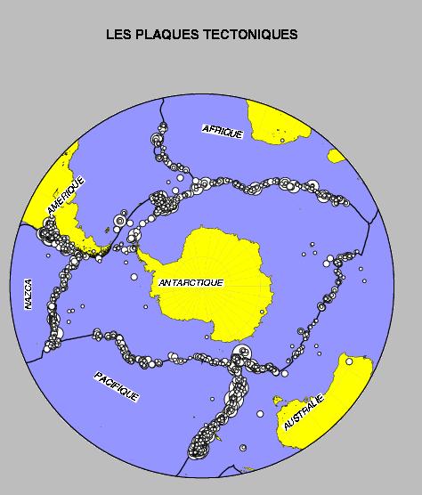
| Tectonic Plates in Southern Hemisphere | The Network of Permanent GPS Sites in Antarctica |
We choose to use data from permanent IGS (International GPS System) sites, because they cover the all continent since 1995, although they are only a few of them. The situation considerably improved from 1995 (only 4 stations) to 1999 (already 9 stations). We contributed to this network by installing a GPS permanent station at the french base of Dumont d'Urville (Terre Adélie) in December 1997. This was done in the framework of the french antarctic programm, funded and coordinated by the french institute for polar research (IFRTP), in collaboration with the french institute for geography (IGN).
The expected displacements are thus made of a superposition of different effects with different time constants and spatial distribution.
The first effect is the Post Glacial Rebound itself : the viscous uplift of the crust due to an important glacial unloading. This uplift is induced by the mass redistribution inside the mantle and it can last thousands of year.
Different types of datat give information on the partial deglaciation which took place on the Antarctic continent since the last glacial maximu 18000 years agoo. Some are indirect information resulting from an inversion of relative sea level records. They are then very much influenced by the uncertainty on the key parameters of crustal and matellic rheology which remain largely unknown. Other type of data, glaciological, allow to determine the amount of Ice which disappeared at given places. Anyways, they have to build a model which include atmospherical, oceanographic, and solid earth coupling, to relate ice erosion rates to global parameters.
Added to the post glacial rebound itself, is the elastic instantaneous response of the solide earth to present day mass variations. They are very few measurements to directely constrained the present day behaviour of the ice cap. The output of GPS measurements directely on the crust is quite obvious : it gives a direct estimation of the present day ice mass imbalance, and then an estimation of the present day ice melting and contribution to mean sea level rise.
Other types of motions : regional tectonics (overall rotation of the Antarctic plate with respect to its neighbours), or local deformations, should be investigated. They are first-order motions which should be understood and eliminated from the measurements to obtaini residual deformations representative of glacial rebound effects.
4- Description of Geodetic Solution
The projection of our measurements in the global reference system (ITRF) was conducted using different techniques : CATREF software (used for combining different data sets to realize the ITRF), and GLOBK (Kalman filtering of epoch measurements), after the initial GPS measurements processing done with the GAMIT (GPS At MIT) software. We used those different techniques to assess the level of coherence and internal precision of the data set. The ultimate solution is produced by combining daily coordinates produced by free network solutions, by the mean of daily 7 parameters (Helmert) transformations to the reference frame. We used both ITRF96 and ITRF97 and produce comparisons. In order to constrain this refernce frame we were conducted to use a certain number of additional stations, outside the Antarctic plate itself. |
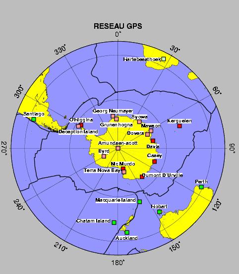
The network of permanent GPS stations used in our computations |
|
5a- Temporal Series at Dumont d'Urville (Terre Adélie) |
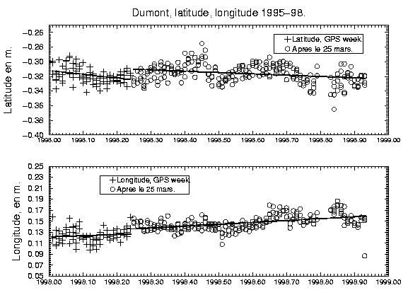
Temporal series at Dumont The cross (resp. the circles) stand for positions before (resp. after) the earthquake. 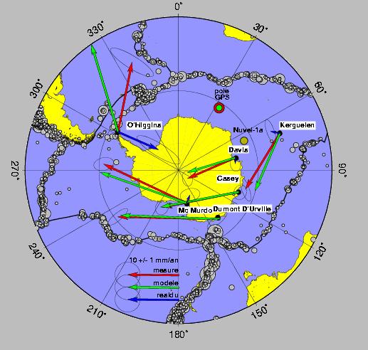
horizontal velocities and position of rotation pole and residuals with respect to this rigid rotation 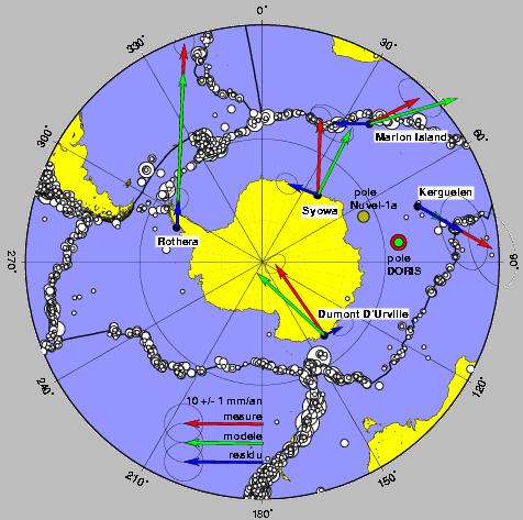
DORIS horizontal velocities, and the estimated pole, and residual velocities |
La seule station où l'on obtient une vitesse résiduelle horizontale non nulle après retrait du mouvement correspondant à la rotation rigide de la plaque tectonique antarctique et l'influence du séisme des Iles Balleny, est celle de O'Higgins située à l'extrémité de la Péninsule. La très bonne cohérence de ce résidu d'une solution à l'autre, et son amplitude de 8 mm/an significative par rapport aux incertitudes nous ont orientés vers une interprétation glaciologique. La Péninsule est la région la plus chaude de tout le continent antarctique, soit la meilleure candidate à une débâcle rapide. Cette vitesse horizontale peut être associée à un retrait élastique instantané vers un centre de décharge glaciaire situé près de la base de la Péninsule (plate-formes de Larsen ou de Filchner-Ronne, sur lesquelles les taux de vêlage sont élevés actuellement). En effet, la croute continentale réagit comme une éponge élastique qui se regonfle (mouvement vertical vers le haut) et qui se rétracte (mouvement horizontal en arričre) quand on arrete d'appuyer dessus (la masse de glace qui diminue). L'amplitude des mouvements horizontaux d'origine flexurale est d'environ 1/3 de celle des mouvements verticaux de rebond élastique correspondants. Ce résidu horizontal de 8 mm/an serait donc cohérente avec le mouvement vertical positif de 25 mm/an que l'on observe sur cette station de O'Higgins.
|
Parmi les vitesses verticales sur le continent antarctique, la plus élevée, dans le sens d'une surrection importante, est celle observée sur cette même station de O'Higgins, avec 25 +/- 12 mm/an. Ce mouvement est trop important, comparé aux autres vitesses verticales des stations antarctiques, pour ne traduire que du rebond visqueux. Il indique certainement une remontée élastique d'au moins 10 à 15 mm/an, correspondant à une évacuation glaciaire actuelle importante au voisinage de la Péninsule. L'application d'une modélisation simple à partir de disques représentant la charge de glace, permet d'évaluer la diminution de l'épaisseur de glace nécessaire pour provoquer un rebond vertical de 1 cm/an à O'Higgins. Si cette diminution est uniforme sur l'ensemble de la Péninsule, il faudrait qu'elle atteigne 65 à 70 cm/an, chiffre important par rapport aux évaluations courantes des modèles, mais qui reste possible, et même comparable à des valeurs locales (par exemple celles du scénario J92 de (Jacobs et al., 1992). Un tel mouvement constitue une indication importante et nouvelle d'une accélération sensible de l'évacuation glaciaire sur la Péninsule. |
Les vitesses verticales mesurées en Antarctique :
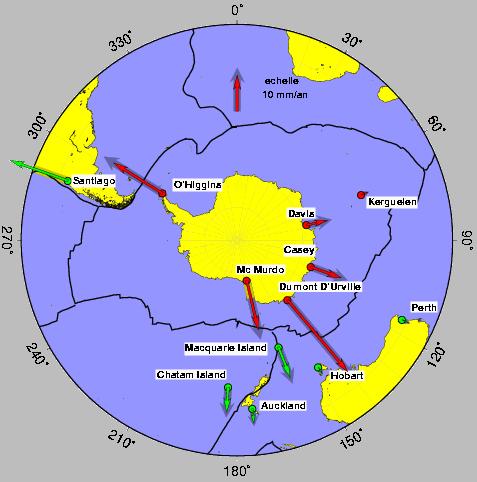
vitesses en plan : les flčches pointant toutes vers l'extérieur indiquent une surrection générale
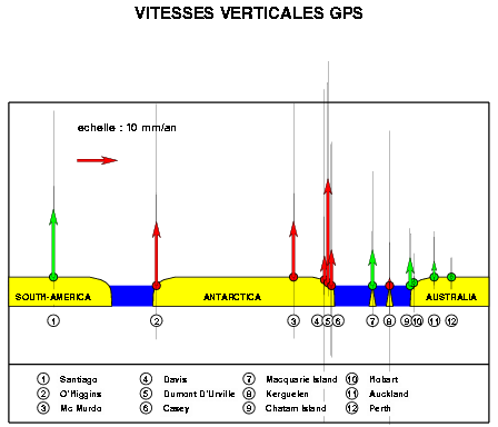
vitesses en coupe : altitude en fonction de la latitude. les barres grises verticales indiquent l'incertitude sur les vitesses |
Les vitesses horizontales, très cohérentes avec une rotation de plaque tectonique rigide, nous fournissent une révision des valeurs de Nuvel1-A pour la vitesse et la position du pôle de rotation de la plaque antarctique.
Sur la station de Dumont, le fait de disposer de séries temporelles continues et précises apporte une mesure d'un déplacement horizontal cosismique.
Les mouvements verticaux confirment l'existence d'un rebond visqueux sur l'ensemble du continent antarctique, peut-être même au delà (stations de Kerguelen et Macquarie). Ils indiquent surtout la présence de rebond élastique sur la pointe de la Péninsule, confirmant par là les observations des glaciologues sur l'accélération récente de la fonte de la calotte Ouest Antarctique.
Les enjeux de ce dernier point sont particulièrement importants, puisque la fonte totale de la partie Ouest de la calotte implique une augmentation du niveau des mers de plus de 6m. L'année 1998 a été celle du GPS en Antarctique, puisque 4 nouvelles stations permanentes fournissent désormais des données accessibles. L'intérêt de la géodésie dans la détection des variations glaciaires n'a jamais été aussi évident, c'est à partir de maintenant que cette nouvelle direction de recherche prend tout son sens.
|
© all results displayed here are extracted from M.N. Bouin PhD. thesis, conducted at "laboratoire de géologie de l'ENS", under co-direction of Ch. Vigny (ENS) et C. Boucher (IGN), defended October 14th, 1999, in front of the jury composed by : F. Barlier (président), K. Lambeck (reviewer), M. Kasser (reviewer), F. Remy (examinor), B. Ambrosius (examinor), C. Boucher, et Ch. Vigny. |