Mobile geophysical instrumentation platform
The ENS Geology Laboratory studies deformation at all time-scales (from geological times to the seconds of seismic ruptures) and space (from laboratory samples to tectonic plates). It does so in the laboratory with its experimental and analytical platforms, but also in the natural environment on specific geographical sites all over the world including two instrumented sites labelled by INSU/CNRS. Geodesic and seismological measurements in situ are one of the main tools of the laboratory’s “Geodynamics and Structures” team (12 researchers and teacher-researchers; 6 of which work directly with geodesic data and 3 with seismological data). As a result, the laboratory manages permanent GNSS networks at dozens of stations on various sites, as well as networks of hundreds of geodesic markers. These instruments must be maintained, these networks must be re-measured periodically. On some sites, there are stations and seismological data. All of these measures produce masses of data that need to be organized and processed for scientific analysis.

© Émilie Klein
Main work sites
- The Gulf of Corinth (Greece)
- The Chilean subduction
- The North Anatolian Fault in Turkey
- Local instruments: sismometer installed in room E319 at the ENS
Platform activities
- February-March – sGPS networks measurements in Atacama, Taltal, S5, Chile/Argentina
- November – Measurement campaign of the sGPS network in Coquimbo, Chili
- October – Field trip Geopotential M2, Var, France
- September – Maintenance mission of the cGPS-sismo networks in Corinth, Greece
- August – Measurement campaign of the sGPS network in Taltal, Chile
- June – Maintenance mission of the cGPS-sismo networks in Corinth, Greece
- March – Measurement of the sGPS network in Atacama, COP2020, Chile
During 2020
During 2019
Instrumental park
Instrumental development and valuation/innovation
Long base inclinometer with optical measurement
Patent France delivered the 21/05/2019 under number FR 2998957
Patent USA delivered the 12/06/2018 under number US 9995579
Patent Europe delivered the 21/11/2018 under number EP 2926085 and validated by the following countries: Germany, France, United Kingdom, Italy and Swiss
Following the ANR LINES (Laser INterferometry for Earth Strains) and as part of a national collaboration (LGENS Paris, IPGP, LAAS OSE Toulouse, Geosciences Montpellier and LSBB), innovative deformation sensors have been developed and coupled by optical fiber to an EFFPI laser interferometer (extrinsic Fabry-Pérot fiber optic interferometer). These developments continue with SATTs (CERN) and FUI MIRZA upgrade projects from 2012 to 2019. At the Geology Laboratory, we have developed and patented a new type of long-base optical inclinometer (patent obtained in France, Europe and the USA).
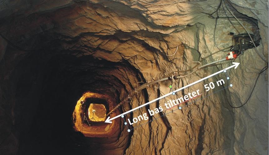
This instrument works according to the simple principle of communicating vessels. It consists of at least 2 pots connected by a tube filled with water (see figure 1 and photo 1). The displacement of the moving mass (pure water) is measured at high resolution (10-9 m) at the ends by a contactless laser beam. For an instrument about 100 m long, we obtain an angular resolution close to 10-11 rad, but also a better long-term stability than the other short-based (~1 m) inclinometers available in the community (vertical drilling inclinometer, pendulum inclinometer or resistive bubble inclinometer). Proportionately, its stability is about 100 times greater. One can obtain a better monthly accuracy than GPS measurements (0.1 mm in relative vertical displacement on a 10 km basis).
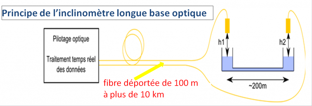
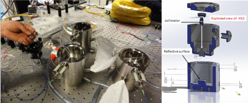
Photo 1b: It does not use any electronics; only an infrared laser beam passes through the liquid and the light signal is deported by optical fiber to 300 m.
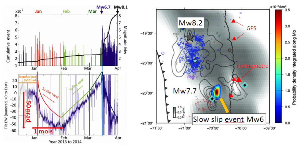
A first station operating without optics with LVDT (Linear Variable Differential Transformer) was installed in the North Chilean seismic gap in 2012. This station was able to observe slow pre-seismic deformations of very small amplitudes (at the limit of detection of GPS measurements) following the major event of Iquique (Mw = 8.2) in 2014 (see figure 2).
Our instruments are also used in the national observatories ORE H+ (OSUR at Geosciences Rennes and LSBB, Underground Low Noise Laboratory, UMS 3538). The objective is to study transfer processes of groundwater masses at high precision.
The new optical features bring other advantages over previous generations of sensors. The patented innovation involves a differential measurement made from a single laser source to reduce costs and filter thermal, atmospheric and electromagnetic noises over the entire frequency band (10-7 Hz – 100 Hz). These innovations and this great stability/precision are essential assets to be coupled with GPS networks and allow observation of very small slow slides on faults.
The absence of electronics inside the sensor provides a great robustness without power supply or intervention on the sensor. Acquisitions of time series can therefore be made over much longer durations, several decades and with a sampling step of up to 10 kHz. Signals deported by optical fiber between 100 m and 10 km distance allow deployments that were once impossible: deep tunnel network installation at the sismo-tectonic sites of our laboratory (see photo 2), but also on radiative, electromagnetic sites such as CERN (particle accelerator) or industrial. High-level metrological control was carried out in collaboration with CERN in Switzerland and the OASIS laboratory at LAAS-CNRS in Toulouse (calibration, sensitivity, instrumental noise, stability and measurement accuracy). This has allowed us to reach technological maturity at the TRL 6 to 7 level.
More recently, we are considering using this deployment capability for seabed installations (ongoing interreg PREST and future MARMOR projects in collaboration with IPGP and IFREMER). The deep seabed is an extremely hostile environment. Accessing it, for the observation and acquisition of scientific data, remains – even today – a challenge, which requires heavy means at sea. We are developing a new pressure sensor coupled with the inclinometer and optical interferometer for installation in Guadeloupe in the Saintes before the end of 2021 at the nearest of recent underwater seismic activity.

© Émilie Klein
Voir aussi dans «Platforms»
Analytical PlatformDedicated to characterization of natural and experimental samples from the different laboratory teams, the analytical platform is composed of a scanning electron microscope, a Raman microspectrometer, an X-Ray diffractometer and a magnetic characterization equipment.
Experimental PlatformThanks to the five instruments of its rock mechanics platform, the LG-ENS can reproduce the Earth's pressure conditions from the surface crust to the asthenospheric mantle. Heating the samples and controlling the fluid pressure allows to get as close as possible to natural conditions.
